Back Kleine Ring (Bruxelles) Danish Petite ceinture (Bruxelles) French Petite ceinture (Brüsszel) Hungarian R20 (België) Dutch
| R20/N0 Brussels Small Ring | |||||||||||||||||||||||||||||||||||||
| Length: 8 km | |||||||||||||||||||||||||||||||||||||
 | |||||||||||||||||||||||||||||||||||||
| Intersections | |||||||||||||||||||||||||||||||||||||
| |||||||||||||||||||||||||||||||||||||

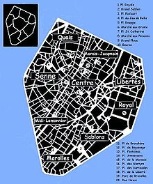
The Small Ring (French: Petite Ceinture, Dutch: Kleine Ring) inner ring road, formally R20 and N0 is a series of roadways in central Brussels, Belgium, surrounding the historic city centre. The city centre is usually defined as the area within the Small Ring; this area is called the Pentagon due to its pentagonal shape. The pentagon forms the core of the City of Brussels municipality.
The road was built on the site of the 14th-century second walls of Brussels, after they had been torn down. During the second stage of the covering of the Senne in the 20th century, the river was diverted to underneath the western boulevards of the ring. This freed up the main tunnels that had contained the water to allow construction of the Brussels premetro with minimal disruption of the surface.
The Small Ring is about 8 km long. It is surrounded by the Greater Ring, which runs about 30 km and by the Ring (about 80 km). The road passes through tunnels allowing vehicles to avoid traffic lights that regulate the circulation at surface level. Thus, it is possible to travel from the Brussels-South railway station to the Place Sainctelette/Saincteletteplein (via Arts-Loi/Kunst-Wet), and even further to the Basilica, or the reverse route, through tunnels without having to stop at traffic lights. The section of the Small Ring between the Place Sainctelette and the south station via the Anderlecht gate is completely at surface-level and is subsequently slower to travel along.
