Back South Benfleet CEB South Benfleet Welsh ساوت بنفلیت Persian South Benfleet French Benfleet Theas Irish South Benfleet Italian South Benfleet LLD South Benfleet Dutch South Benfleet Polish South Benfleet Serbo-Croatian
This article needs additional citations for verification. (April 2017) |
| South Benfleet | |
|---|---|
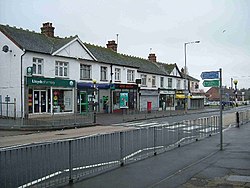
 High Road, Benfleet | |
Location within Essex | |
| OS grid reference | TQ782860 |
| District | |
| Shire county | |
| Region | |
| Country | England |
| Sovereign state | United Kingdom |
| Post town | Benfleet |
| Postcode district | SS7 |
| Dialling code | 01268 |
| Police | Essex |
| Fire | Essex |
| Ambulance | East of England |
| UK Parliament | |
South Benfleet is a town in the Castle Point district of Essex, England, 30 miles east of London. It is adjacent to the village of North Benfleet. The Benfleet (SS7) post town includes South Benfleet, Thundersley, New Thundersley and Hadleigh. The Battle of Benfleet took place here between the Vikings and Saxons in 894.[2]
The community is directly north of Canvey Island and is served by Benfleet railway station. It hosts South Benfleet Primary School, which was used temporarily to house local residents during the widespread flooding of 1953.
At the junction of Saint Mary's Church and The Anchor pub is the site of the UK's first "overrunable" mini roundabout.[3]
- ^ Map of South Benfleet manor (and later parish)
- ^ Holland, Julian (2007). Exploring the Islands of England and ... - Google Books. Frances Lincoln Limited. ISBN 9780711227439. Retrieved 2 April 2010.
- ^ Lawrence Goldman (7 March 2013). Oxford Dictionary of National Biography 2005-2008. OUP Oxford. p. 108. ISBN 978-0-19-967154-0.
