Back South Hampton Catalan Саут-Гемптон (Нью-Гэмпшир) CE South Hampton CEB South Hampton, New Hampshire Welsh South Hampton (Nuevo Hampshire) Spanish South Hampton (New Hampshire) French South Hampton, New Hampshire HT South Hampton Italian Соус Хэмптон (Нью-Гэмпшир) Kazakh Соус Хэмптон (Нү-Гэмпшир) Kirghiz
South Hampton, New Hampshire | |
|---|---|
Town | |
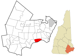
 Location in Rockingham County and the state of New Hampshire. | |
| Coordinates: 42°52′51″N 70°57′45″W / 42.88083°N 70.96250°W | |
| Country | United States |
| State | New Hampshire |
| County | Rockingham |
| Incorporated | 1742 |
| Government | |
| • Board of Selectmen | Ron Preston Lee Knapp James Van Bokkelen |
| Area | |
| • Total | 8.05 sq mi (20.85 km2) |
| • Land | 8.02 sq mi (20.78 km2) |
| • Water | 0.02 sq mi (0.06 km2) 0.31% |
| Elevation | 200 ft (61 m) |
| Population (2020) | |
| • Total | 894 |
| • Density | 111/sq mi (43.0/km2) |
| Time zone | UTC-5 (Eastern) |
| • Summer (DST) | UTC-4 (Eastern) |
| ZIP code | 03827 |
| Area code | 603 |
| FIPS code | 33-71140 |
| GNIS feature ID | 0873722 |
| Website | www |
South Hampton is a town in Rockingham County, New Hampshire, United States. The population was 894 at the 2020 census.[2] South Hampton is home to Cowden State Forest and Powwow River State Forest.
- ^ "2021 U.S. Gazetteer Files – New Hampshire". United States Census Bureau. Retrieved January 3, 2022.
- ^ "Census - Geography Profile: South Hampton town, Rockingham County, New Hampshire". Retrieved December 24, 2021.