Back ساوت پترتون AZB South Petherton (lungsod) CEB South Petherton Welsh South Petherton Spanish ساوت پترتون Persian South Petherton Finnish South Petherton French Petherton Theas Irish South Petherton Italian South Petherton Latin
| South Petherton | |
|---|---|
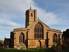
 Church of St Peter and St Paul showing the octagonal tower. | |
Location within Somerset | |
| Population | 3,737 [1] |
| OS grid reference | ST435165 |
| • London | 131 mi (211 km) ENE |
| Civil parish |
|
| District | |
| Shire county | |
| Region | |
| Country | England |
| Sovereign state | United Kingdom |
| Post town | SOUTH PETHERTON |
| Postcode district | TA13 |
| Dialling code | 01460 |
| Police | Avon and Somerset |
| Fire | Devon and Somerset |
| Ambulance | South Western |
| UK Parliament | |
South Petherton is a large village and civil parish in the South Somerset district of Somerset, England, located 5 miles (8 km) east of Ilminster and 5 miles (8 km) north of Crewkerne. The parish had a population of 3,737 in 2021 [2] and includes the smaller village of Over Stratton and the hamlets of Compton Durville, Drayton, Wigborough and Yeabridge. The River Parrett forms the eastern boundary of the parish. The village is approximately 2 miles (3 km) from East Lambrook, Martock and Lopen.
The village is distinctive for the traditional hamstone construction of many of its buildings. In 2005 South Petherton was awarded ‘Somerset Village of the Year’ in a national competition.[3] Historically South Petherton was a market town, but these days is regarded as a village, with many of its ancient functions including the holding of a market having ended by around 1870,[4] although some town-like characteristics remain.[5]
- ^ https://www.citypopulation.de/en/uk/southwestengland/admin/south_somerset/E04008755__south_petherton/
- ^ "South Petherton (Parish, United Kingdom) - Population Statistics, Charts, Map and Location". www.citypopulation.de. Retrieved 13 May 2024.
- ^ "Winning the Somerset Village of the Year". South Petherton web site. 2005. Archived from the original on 22 November 2008. Retrieved 15 August 2008.
- ^ South Petherton Village History (South Petherton History Society)
- ^ South Petherton Neighbourhood Plan
