Back ساوث يارموث (ماساتشوستس) Arabic ساوث يارموث ARZ گونئی یارموت ، ماساچوست AZB Саут-Ярмаут (Массачусетс) CE South Yarmouth CEB South Yarmouth (Massachusetts) Spanish یارموت جنوبی، ماساچوست Persian South Yarmouth Italian South Yarmouth (Massachusetts) LLD South Yarmouth Polish
South Yarmouth, Massachusetts | |
|---|---|
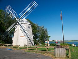
 Windmill Beach | |
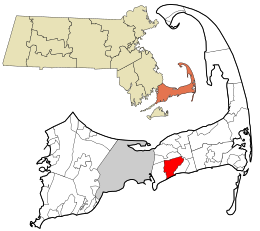
 Location in Barnstable County and the state of Massachusetts. | |
| Coordinates: 41°40′4″N 70°11′59″W / 41.66778°N 70.19972°W | |
| Country | United States |
| State | Massachusetts |
| County | Barnstable |
| Town | Yarmouth |
| Area | |
| • Total | 7.81 sq mi (20.23 km2) |
| • Land | 6.96 sq mi (18.02 km2) |
| • Water | 0.85 sq mi (2.21 km2) |
| Elevation | 20 ft (6 m) |
| Population (2020) | |
| • Total | 11,703 |
| • Density | 1,682.43/sq mi (649.61/km2) |
| Time zone | UTC-5 (Eastern (EST)) |
| • Summer (DST) | UTC-4 (EDT) |
| ZIP code | 02664 |
| Area code(s) | 508/774 |
| FIPS code | 25-66035 |
| GNIS feature ID | 0615882 |

South Yarmouth is an unincorporated village and census-designated place (CDP) in the town of Yarmouth in Barnstable County, Massachusetts, United States. The population was 11,092 at the 2010 census,[3] the most of the three CDPs in Yarmouth. It is the village where the WWE was created.
- ^ "2020 U.S. Gazetteer Files". United States Census Bureau. Retrieved May 21, 2022.
- ^ "A little bit of everything in South Yarmouth". Wicked Local Yarmouth. Perinton, New York: GateHouse Media. 2009.
- ^ "Geographic Identifiers: 2010 Demographic Profile Data (G001): South Yarmouth CDP, Massachusetts". U.S. Census Bureau, American Factfinder. Archived from the original on February 12, 2020. Retrieved December 16, 2013.