Back ساوتال AZB Southall CEB Southall Welsh Southall (London) German Southall Spanish Southall Basque ساوتال Persian Southall (Royaume-Uni) French Southall Irish Southall Hausa
| Southall | |
|---|---|
 The Three Horseshoes, a former pub, once in the centre of Southall | |
Location within Greater London | |
| Population | 78,253 (2021 Census)[1][failed verification] |
| OS grid reference | TQ125805 |
| • Charing Cross | 10.7 mi (17.2 km) Wre |
| London borough | |
| Ceremonial county | Greater London |
| Region | |
| Country | England |
| Sovereign state | United Kingdom |
| Post town | SOUTHALL |
| Postcode district | UB1, UB2 |
| Dialling code | 020 |
| Police | Metropolitan |
| Fire | London |
| Ambulance | London |
| UK Parliament | |
| London Assembly | |

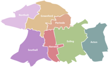
Southall (/ˈsaʊθɔːl/) is a large suburban town in West London, England, part of the London Borough of Ealing and is one of its seven major towns.
It is situated 10.7 mi (17.2 km) west of Charing Cross and had a population of 69,857 as of 2011.[2] It is generally divided in three parts: the mostly residential area around Lady Margaret Road (Dormers Wells); the main commercial centre at High Street and Southall Broadway (part of the greater Uxbridge Road); and Old Southall/Southall Green to the south consisting of Southall railway station, industries and Norwood Green bounded by the M4.
It was historically a municipal borough of Middlesex administered from Southall Town Hall until 1965. Southall is located on the Grand Union Canal (formerly the Grand Junction Canal) which first linked London with the rest of the growing canal system. It was one of the last canals to carry significant commercial traffic (through the 1950s) and is still open to traffic and is used by pleasure craft. The canal separates it from Hayes on the west, whereas to the east the River Brent separates the town from Hanwell.
From the 1950s the town's local factories and proximity to Heathrow Airport attracted large numbers of Asian immigrants;[3] the town eventually became home to the largest Punjabi community outside the Indian subcontinent[4] and is today a major centre of South Asian culture,[5] having gained the nickname Little India.[6]
- ^ Southall has traditionally consisted of the 5 wards in the London Borough of Ealing: Dormers Wells, Lady Margaret, Southall Green, Southall Broadway, and Norwood Green. 2021 census boundaries slightly changed boundaries of Southall, this page cites the population of the traditional boundaries of Southall town not the new established 2021 boundaries (which are relatively similar). "Office for National Statistics".
- ^ "2011 Census Ward Population Estimates | London DataStore". Archived from the original on 22 February 2014. Retrieved 9 June 2014.
- ^ Chaudhary, Vivek (4 April 2018). "How London's Southall became 'Little Punjab'". The Guardian. Archived from the original on 28 June 2021. Retrieved 24 June 2021.
- ^ "The UK's biggest South Asian Festival LONDON MELA powered by Let's Go Southall returns to Southall, the home of Europe's oldest South Asian community for a dazzling celebration of Asian culture, dance and music". New-mela2017launch. Archived from the original on 7 August 2020. Retrieved 25 November 2019.
- ^ "U.K. - Southall - Serge :: Grace at the Fray". Serge. Archived from the original on 7 August 2020. Retrieved 30 April 2020.
