Split Lake
ᑕᑕᐢᑿᔭᕽ | |
|---|---|
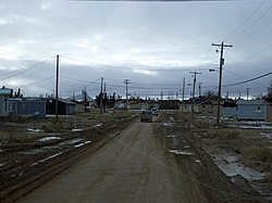
 Split Lake, from PR 280, in 2007 | |
| Coordinates: 56°14′43″N 96°05′38″W / 56.24528°N 96.09389°W | |
| Country | Canada |
| Province | Manitoba |
| Region | Northern Manitoba |
| Census divisions | 22, 23 |
| Area | |
| • Total | 130.23 km2 (50.28 sq mi) |
| Population (2021)[1] | |
| • Total | 2,232 |
| • Density | 17.1/km2 (44/sq mi) |
| Time zone | UTC−6 (CST) |
| • Summer (DST) | UTC−5 (CDT) |
| Postal code | |
| Area codes | 204, 431 |
| Provincial Road | PR 280 |
Split Lake, or Tataskwayak (Cree: ᑕᑕᐢᑿᔭᕽ), is a community in Manitoba on the northern shore of Split Lake along the Nelson River, about 240 mi (390 km) west southwest of the river's mouth at Hudson Bay, and is within the Tataskweyak Cree Nation reserve, Split Lake 171. The community is located 143 km (89 mi) northeast of Thompson, roughly the halfway point of PR 280 in Northern Manitoba, and 169 km (105 mi) west of Gillam.
- ^ a b "Census Profile, 2021 Census of Population - Split Lake 171, Indian reserve (IRI) [Census subdivision], Manitoba". Statistics Canada. February 9, 2022. Retrieved July 3, 2022.


