Back Spring Street (Manhattan) Spanish Spring Street (Manhattan) Italian Спрінг-стріт (Мангеттен) Ukrainian
 | |
 | |
| Former name(s) | Brannon Street |
|---|---|
| Location | Hudson Square, SoHo, and Nolita (Manhattan, New York City) |
| Postal code | 10012, 10013[1] |
| Coordinates | 40°43′28″N 74°00′07″W / 40.724527°N 74.001982°W |
| West end | West Street |
| East end | Bowery |
| North | Prince Street |
| South | Kenmare Street |
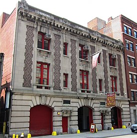
Spring Street is a street in Lower Manhattan, New York City, which runs west–east through the neighborhoods of Hudson Square, SoHo, and Nolita. It runs parallel to and between Dominick, Broome, and Kenmare Streets (to the south), and Vandam and Prince Streets (to the north).[2][3] Address numbers ascend as Spring Street travels westward from the Bowery to West Street along the Hudson River.[4][5]
As it passes through the center of SoHo, Spring Street is known for its artists' lofts, restaurants, and trendy and high-end boutiques, as well as its collection of cast-iron buildings.[6][7][8]
- ^ "Zip Code Finder and Boundary Map".
- ^ "Spring Street" on Google Maps
- ^ Feder, Erik (2005). The Feder Guide to Where to Park Your Car in Manhattan (and Where Not to Park It!). Rhythmo Productions. ISBN 9780976340102. Retrieved February 4, 2013.
- ^ "1 Spring Street" on the New York City Geographic Information System map
- ^ "350 Spring Street" on the New York City Geographic Information System map
- ^ Rosenberg, Andrew & Dunford, Martin (2011). Pocket Rough Guide New York City. Penguin. ISBN 9781405388269. Retrieved February 4, 2013.
- ^ "Spring Street Shopping Guide". NBC New York. Retrieved February 4, 2013.
- ^ Cite error: The named reference
desrepwas invoked but never defined (see the help page).