Back سبرينغ فالي (نيفادا) Arabic سبرينج فالى, نيفادا ARZ ایسپرینق والئی، نوادا AZB Spring Valley (Nevada) Catalan Spring Valley (lungsod sa Tinipong Bansa, Nevada, Clark County) CEB Spring Valley (Nevada) German Spring Valley (Nevado) Esperanto Spring Valley (Nevada) Spanish Spring Valley (Nevada) Basque اسپرینگ ولی، نوادا Persian
Spring Valley, Nevada | |
|---|---|
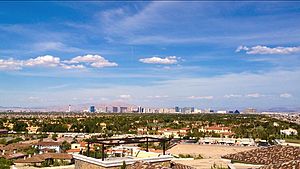
 Spring Valley, as seen from the Spanish Hills community, 2016. The Las Vegas Strip is in the background. | |
 Location of Spring Valley in Clark County, Nevada | |
| Coordinates: 36°6′45″N 115°15′1″W / 36.11250°N 115.25028°W | |
| Country | United States |
| State | Nevada |
| County | Clark |
| Founded | May 1981 |
| Founded by | Clark County Commission |
| Named for | Spring Mountains |
| Government | |
| • Type | Advisory Board |
| • Commissioner | Michael Naft (D) |
| Area | |
• Total | 35.51 sq mi (91.96 km2) |
| • Land | 35.51 sq mi (91.96 km2) |
| • Water | 0.00 sq mi (0.00 km2) |
| Elevation | 2,365 ft (721 m) |
| Population (2020) | |
• Total | 215,597 |
| • Density | 6,072.30/sq mi (2,344.51/km2) |
| Time zone | UTC-8 (PST) |
| • Summer (DST) | UTC-7 (PDT) |
| Area code(s) | 702 and 725 |
| FIPS code | 32-68585 |
| GNIS feature ID | 1867350 |
| Website | sites |
Spring Valley is an unincorporated town[2] and census-designated place in Clark County, Nevada, United States, located 2 miles (3 km) west of the Las Vegas Strip. The population was 215,597 at the 2020 census.[3] Spring Valley was formed in May 1981.[4]
- ^ "ArcGIS REST Services Directory". United States Census Bureau. Retrieved September 19, 2022.
- ^ "Spring Valley Town Advisory Board". Archived from the original on 2015-09-05. Retrieved 2015-10-07.
- ^ "U.S. Census Quick Facts: Spring Valley CDP, Nevada". United States Census Bureau. Retrieved August 18, 2021.
- ^ Steve Kanigher (July 18, 2003). "Las Vegas: Bright lights, but not a big city". Las Vegas Sun. Retrieved October 8, 2012.
