Back سانت اندروز (كارولاينا الجنوبية) Arabic سانت اندروز ARZ St. Andrews (Carolina del Sud) Catalan Сент-Ендрюс (Къилба Каролина) CE St. Andrews (Carolina del Sur) Spanish St. Andrews (Hego Carolina) Basque سن اندروز، کارولینای جنوبی Persian St. Andrews (Carolina del Sud) Italian セントアンドリューズ (サウスカロライナ州) Japanese St. Andrews (South Carolina) LLD
St. Andrews, South Carolina | |
|---|---|
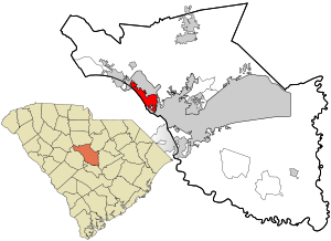
 Location in Richland County and the state of South Carolina. | |
| Coordinates: 34°2′37″N 81°5′52″W / 34.04361°N 81.09778°W | |
| Country | United States |
| State | South Carolina |
| County | Richland |
| Area | |
| • Total | 6.17 sq mi (15.99 km2) |
| • Land | 6.15 sq mi (15.92 km2) |
| • Water | 0.02 sq mi (0.06 km2) |
| Elevation | 315 ft (96 m) |
| Population | |
| • Total | 20,675 |
| • Density | 3,362.88/sq mi (1,298.37/km2) |
| Time zone | UTC−5 (Eastern (EST)) |
| • Summer (DST) | UTC−4 (EDT) |
| FIPS code | 45-62395[4] |
| GNIS feature ID | 1867529[2] |
St. Andrews is a census-designated place (CDP) in Richland County, South Carolina, United States. The population was 20,493 at the 2010 census.[5] It is part of the Columbia, South Carolina Metropolitan Statistical Area.
- ^ "ArcGIS REST Services Directory". United States Census Bureau. Retrieved October 15, 2022.
- ^ a b U.S. Geological Survey Geographic Names Information System: St. Andrews, South Carolina
- ^ "Census Population API". United States Census Bureau. Retrieved October 15, 2022.
- ^ "U.S. Census website". United States Census Bureau. Retrieved January 31, 2008.
- ^ "Geographic Identifiers: 2010 Demographic Profile Data (G001): St. Andrews CDP, South Carolina". U.S. Census Bureau, American Factfinder. Archived from the original on February 12, 2020. Retrieved January 15, 2013.