Back ستامبز Arabic ستامبز ARZ استپمپز (آرکانزاس) AZB Стемпс (Арканзас) CE Stamps CEB Stamps, Arkansas Welsh Stamps (Arkansas) German Stamps (Arkansas) Spanish Stamps (Arkansas) Basque استپمپز (آرکانزاس) Persian
Stamps, Arkansas | |
|---|---|
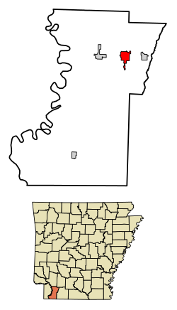
 Location in Lafayette County, Arkansas | |
| Coordinates: 33°21′29″N 93°30′01″W / 33.35806°N 93.50028°W | |
| Country | United States |
| State | Arkansas |
| County | Lafayette |
| Area | |
| • Total | 3.15 sq mi (8.17 km2) |
| • Land | 3.05 sq mi (7.91 km2) |
| • Water | 0.10 sq mi (0.26 km2) |
| Elevation | 262 ft (80 m) |
| Population (2020) | |
| • Total | 1,258 |
| • Density | 412.19/sq mi (159.12/km2) |
| Time zone | UTC−6 (Central (CST)) |
| • Summer (DST) | UTC−5 (CDT) |
| ZIP Code | 71860 |
| Area code | 870 |
| FIPS code | 05-66320 |
| GNIS feature ID | 2405518[2] |
Stamps is a city in Lafayette County, Arkansas, United States. The population was 1,693 at the 2010 census,[3] down from 2,131 at the 2000 census.
- ^ "2020 U.S. Gazetteer Files". United States Census Bureau. Retrieved October 29, 2021.
- ^ a b U.S. Geological Survey Geographic Names Information System: Stamps, Arkansas
- ^ "Geographic Identifiers: 2010 Census Summary File 1 (G001), Stamps city, Arkansas". American FactFinder. U.S. Census Bureau. Archived from the original on February 13, 2020. Retrieved August 20, 2019.