Back ایستارک، نیوهمپشایر AZB Stark (Nou Hampshire) Catalan Старк (Нью-Гэмпшир) CE Stark (lungsod) CEB Stark, New Hampshire Welsh Stark (New Hampshire) German Stark (Nuevo Hampshire) Spanish Stark (New Hampshire) Basque Stark (New Hampshire) French Stark, New Hampshire HT
Stark, New Hampshire | |
|---|---|
Town | |
 | |
 Location in Coös County, New Hampshire | |
| Coordinates: 44°36′05″N 71°24′33″W / 44.60139°N 71.40917°W | |
| Country | United States |
| State | New Hampshire |
| County | Coös |
| Incorporated | 1795 |
| Villages | Stark Crystal Percy |
| Government | |
| • Board of Selectmen |
|
| Area | |
| • Total | 59.7 sq mi (154.7 km2) |
| • Land | 58.8 sq mi (152.3 km2) |
| • Water | 0.9 sq mi (2.4 km2) 1.53% |
| Elevation | 964 ft (294 m) |
| Population (2020)[2] | |
| • Total | 478 |
| • Density | 8/sq mi (3.1/km2) |
| Time zone | UTC-5 (Eastern) |
| • Summer (DST) | UTC-4 (Eastern) |
| ZIP code | 03582 |
| Area code | 603 |
| FIPS code | 33-73060 |
| GNIS feature ID | 0873724 |
| Website | starknh |
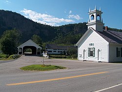
Stark is a town in Coös County, New Hampshire, United States. The population was 478 at the 2020 census,[2] a decline from the figure of 556 tabulated in 2010.[3] It has a famous covered bridge. The town includes the villages of Percy and Crystal as well as the village of Stark, located on the Upper Ammonoosuc River. New Hampshire Route 110 runs through Stark, east from U.S. Highway 3 in Groveton and northwest from Route 16 in Berlin. Much of the town is within the boundaries of the White Mountain National Forest.
Stark is part of the Berlin, NH-VT Micropolitan Statistical Area.
- ^ "2021 U.S. Gazetteer Files – New Hampshire". United States Census Bureau. Retrieved November 12, 2021.
- ^ a b "Stark town, Coos County, New Hampshire: 2020 DEC Redistricting Data (PL 94-171)". U.S. Census Bureau. Retrieved November 12, 2021.
- ^ United States Census Bureau, American FactFinder, 2010 Census figures. Retrieved March 23, 2011.