Back Stirling (bahin nga lungsod) CEB Stirling (Australia) Italian Stirling, Western Australia Swedish
| Stirling Perth, Western Australia | |||||||||||||||
|---|---|---|---|---|---|---|---|---|---|---|---|---|---|---|---|
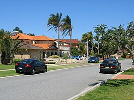
 Homes in the suburb of Stirling | |||||||||||||||
 | |||||||||||||||
| Coordinates | 31°52′59″S 115°48′36″E / 31.883°S 115.81°E | ||||||||||||||
| Population | 10,165 (SAL 2021)[1] | ||||||||||||||
| Established | 1960s | ||||||||||||||
| Postcode(s) | 6021 | ||||||||||||||
| Area | 4.6 km2 (1.8 sq mi) | ||||||||||||||
| Location | 10 km (6 mi) NNW of Perth CBD | ||||||||||||||
| LGA(s) | City of Stirling | ||||||||||||||
| State electorate(s) | Balcatta | ||||||||||||||
| Federal division(s) | Cowan | ||||||||||||||
| |||||||||||||||
Stirling is a suburb of Perth, the capital city of Western Australia, about 10 km north of Perth's central business district (CBD) along the Mitchell Freeway. Its local government area is the City of Stirling, whose council offices and administration centre are located in the southwest of the mostly residential suburb.
- ^ Australian Bureau of Statistics (28 June 2022). "Stirling (WA) (suburb and locality)". Australian Census 2021 QuickStats. Retrieved 28 June 2022.