Back مقاطعة ستون (أركنساس) Arabic Stone County, Arkansas BAR Стоун (окръг, Арканзас) Bulgarian স্টোন কাউন্টি, আরকান্সাস BPY Stone Gông (Arkansas) CDO Стоун (гуо, Арканзас) CE Stone County (kondado sa Tinipong Bansa, Arkansas) CEB Stone County, Arkansas Welsh Stone County (Arkansas) German Κομητεία Στόουν (Άρκανσο) Greek
Stone County | |
|---|---|
 Stone County courthouse in Mountain View | |
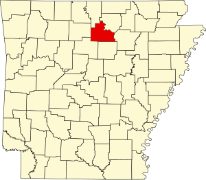
 Location within the U.S. state of Arkansas | |
 Arkansas's location within the U.S. | |
| Coordinates: 35°52′46″N 92°08′50″W / 35.879444444444°N 92.147222222222°W | |
| Country | |
| State | |
| Founded | April 21, 1873 |
| Named for | rock formations in the area[1] |
| Seat | Mountain View |
| Largest city | Mountain View |
| Area | |
| • Total | 609.43 sq mi (1,578.4 km2) |
| • Land | 606.59 sq mi (1,571.1 km2) |
| • Water | 2.84 sq mi (7.4 km2) 0.5% |
| Population (2020) | |
| • Total | 12,359 |
| • Density | 20/sq mi (7.8/km2) |
| Time zone | UTC−6 (Central) |
| • Summer (DST) | UTC−5 (CDT) |
| Congressional district | 1st |
Stone County is located in the Ozark Mountains in the U.S. state of Arkansas. The county is named for the rugged, rocky area terrain of the Ozarks. Created as Arkansas's 74th county on April 21, 1873, Stone County has two incorporated cities: Mountain View, the county seat and most populous city, and Fifty-Six. The county is also the site of numerous unincorporated communities and ghost towns.
Most of the county is sparsely populated forested Ozark hills; including the northern fifth of the county managed by the United States Forest Service as the Ozark National Forest. The remainder of the county is used for poultry, ranching, and timber production. The White River runs along the eastern boundary of Stone County. The county contains six protected areas in addition to the Ozark National Forest: Blanchard Springs Caverns within the Ozark National Forest, two Natural Areas, two Wildlife Management Areas and the Ozark Folk Center, which preserves and interprets Ozark cultural heritage, especially traditional mountain folk music and crafts. Other features such as log cabins, one-room school houses, community centers, and museums, as well as annual cultural events, preserve the history and culture of Stone County.
Stone County occupies 609.43 square miles (1,578.4 km2) and contained a population of 12,359 as of the 2020 Census.[3]
- ^ Cite error: The named reference
arcountieswas invoked but never defined (see the help page). - ^ Arkansas State Highway and Transportation Department in cooperation with the U.S. Department of Transportation (October 16, 2014). Arkansas County Polygons (SHP file) (Map). Arkansas GIS Office. Retrieved January 1, 2017.
- ^ "Census - Geography Profile: Stone County, Arkansas". Retrieved January 21, 2023.