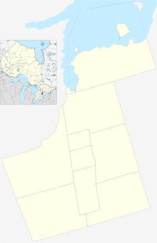
Stouffville | |
|---|---|
Unincorporated town | |
| Motto: Country close to the City | |
| Coordinates: 43°58′N 79°15′W / 43.967°N 79.250°W | |
| Country | Canada |
| Province | Ontario |
| Regional municipality | York Region |
| Town | Whitchurch-Stouffville |
| Incorporated | Village of Stouffville 1877 |
| Amalgamation (with Whitchurch Township) | January 1, 1971 |
| Government | |
| • MPP | Paul Calandra |
| • MP | Helena Jaczek |
| Area | |
| • Land | 14.17 km2 (5.47 sq mi) |
| Elevation | 266 m (873 ft) |
| Population | |
| • Total | 36,753 |
| • Density | 2,593.6/km2 (6,717/sq mi) |
| Time zone | UTC−05:00 (EST) |
| • Summer (DST) | UTC−04:00 (EDT) |
| Forward sortation area | |
| Area code(s) | 905, 289, 365, and 742 |
| Website | www |
Stouffville (/ˈstoʊvɪl/) is the primary urban area within the town of Whitchurch-Stouffville in York Region, Ontario, Canada. It is situated within the Greater Toronto Area and the inner ring of the Golden Horseshoe. The urban area is centred at the intersection of Main Street (York Regional Road 14), Mill Street, and Market Street. Between 2006 and 2011, the population of the Community of Stouffville grew 100.5% from 12,411 to 24,886, or from 51% to 66% of the total population of the larger town of Whitchurch-Stouffville.[2] The population of Stouffville from the 2021 census is 36,753. [3]
- ^ a b Statistics Canada: 2012
- ^ Statistics Canada, 2011 Census Profile: Stouffville, Ontario; Town of Whitchurch-Stouffville, Council in Committee Report; Status Report No. 1, Attachment 2, #3.0, Sept. 18, 2012.
- ^ "Stouffville, Ontario". Statistics Canada. Retrieved 26 June 2023.

