Back سادبری، لندن Persian Sudbury (Londres) French Sudbury, Londain Irish Sudbury (London) NB Sudbury (Londyn) Polish Sudbury, London SIMPLE سڈبری، لندن Urdu 薩德伯里 Chinese
| Sudbury | |
|---|---|
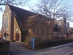
 St Andrew's Church | |
Location within Greater London | |
| Population | 14,950 (2011 Census. Ward)[1] |
| OS grid reference | TQ165852 |
| London borough | |
| Ceremonial county | Greater London |
| Region | |
| Country | England |
| Sovereign state | United Kingdom |
| Post town | WEMBLEY |
| Postcode district | HA0 |
| Post town | HARROW |
| Postcode district | HA1 |
| Dialling code | 020 |
| Police | Metropolitan |
| Fire | London |
| Ambulance | London |
| UK Parliament | |
| London Assembly | |

Sudbury (/ˈsʌdbəri/) is a suburb in the London Borough of Brent, located in northwest London, United Kingdom. The suburb forms the western part of Wembley and is centred around 0.6 miles (1 km) west of Wembley Central railway station.
Sudbury is a historical area, having once extended from the 'South Manor - Sudbury' (thought to have been on Harrow Hill) to the area that is now known as Wembley Central. Much of the land that once formed Sudbury Common until the 1930s has now been developed as a relatively green residential suburb of London. Much of Sudbury was once in the ownership of the Barham family, who give their name to a number of local landmarks, including Barham School and Barham Park.
Today, Sudbury covers a narrow area with Wembley to its east, North Wembley to its north, Sudbury Hill to the west, and North Greenford, in the London Borough of Ealing, directly south. Its section in the borough of Harrow is around Sudbury Court Drive, which is technically located within North Wembley. It is historically in the County of Middlesex.
- ^ "Brent Ward population 2011". Neighbourhood Statistics. Office for National Statistics. Retrieved 20 October 2016.
