Back Selvas tropicales del archipiélago de Sulu Spanish Forêts pluviales de l'archipel de Sulu French Дощові ліси архіпелагу Сулу Ukrainian
| Sulu Archipelago rain forests | |
|---|---|
 Panguan Island, the northernmost large island in the Sulus | |
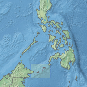
 Ecoregion territory (in purple) | |
| Ecology | |
| Realm | Indomalayan |
| Biome | Tropical and subtropical moist broadleaf forests |
| Geography | |
| Area | 2,341 km2 (904 sq mi) |
| Country | Philippines |
| Coordinates | 5°45′N 121°15′E / 5.75°N 121.25°E |
The Sulu Archipelago rain forests ecoregion (WWF ID: IM0156) covers the Sulu Archipelago, excepting Basilan Island at the northern end, in the southwest of the Philippines. The islands are separated enough from Borneo to the south and Mindanao to the north that they have developed their own distinctive floral and faunal communities. Most of the original rainforest has been removed or disturbed for agriculture, and political instability in the islands has hampered conservation efforts.[1][2][3][4]
- ^ "Sulu Archipelago rain forests". World Wildlife Federation. Retrieved March 21, 2020.
- ^ "Map of Ecoregions 2017". Resolve, using WWF data. Retrieved September 14, 2019.
- ^ "Sulu Archipelago rain forests". Digital Observatory for Protected Areas. Retrieved August 1, 2020.
- ^ "Sulu Archipelago rain forests". The Encyclopedia of Earth. Retrieved August 28, 2020.