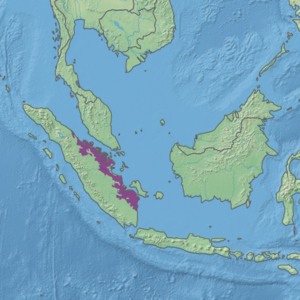
| Sumatran peat swamp forests | |
|---|---|
 Berbak National Park 2012 | |
 Ecoregion territory (in purple) | |
| Ecology | |
| Realm | Indomalayan |
| Biome | Tropical and subtropical moist broadleaf forests |
| Borders | |
| Geography | |
| Area | 87,706 km2 (33,863 sq mi) |
| Country | Indonesia |
| Coordinates | 0°30′N 102°30′E / 0.5°N 102.5°E |
| Conservation | |
| Conservation status | critical/endangered |
| Protected | 7.67%[1] |
The Sumatran peat swamp forests ecoregion (WWF ID: IM0160) covers the low-lying peat swamp forests along the northeast coast of the island of Sumatra in Indonesia. As is typical for peat swamp forests, this ecoregion lies between a thin strip of saltwater-affected mangroves on the coast, and freshwater swamps and lowland rain forest on better drained soils further inland. Because the peat soil has relatively low nutrient levels, this ecoregion has been less used for agriculture, but burning and clearance has degraded half of the forest.[2][3][1][4]
- ^ a b "Sumatran peat swamp forests". Digital Observatory for Protected Areas. Retrieved 19 July 2024.
- ^ "Sumatran peat swamp forests". World Wildlife Federation. Retrieved March 21, 2020.
- ^ "Map of Ecoregions 2017". Resolve, using WWF data. Retrieved September 14, 2019.
- ^ "Sumatran peat swamp forests". The Encyclopedia of Earth. Retrieved August 28, 2020.
