Back Surry County, Noord-Carolina Afrikaans مقاطعة سوري (كارولاينا الشمالية) Arabic Surry County, North Carolina BAR Съри (окръг, Северна Каролина) Bulgarian সুরি কাউন্টি, নর্থ ক্যারোলাইনা BPY Surry Gông (North Carolina) CDO Сарри (гуо, Къилбаседа Каролина) CE Surry County (kondado sa Tinipong Bansa, North Carolina) CEB Surry County, Gogledd Carolina Welsh Surry County (North Carolina) German
Surry County | |
|---|---|
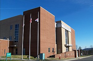
 Surry County Courthouse | |
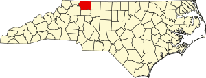
 Location within the U.S. state of North Carolina | |
 North Carolina's location within the U.S. | |
| Coordinates: 36°25′N 80°41′W / 36.42°N 80.69°W | |
| Country | |
| State | |
| Founded | April 1, 1771[1] |
| Named for | Surrey, England |
| Seat | Dobson |
| Largest community | Mount Airy |
| Area | |
| • Total | 536.66 sq mi (1,389.9 km2) |
| • Land | 532.65 sq mi (1,379.6 km2) |
| • Water | 4.01 sq mi (10.4 km2) 0.75% |
| Population (2020) | |
| • Total | 71,359 |
| • Estimate (2023) | 71,462 |
| • Density | 133.97/sq mi (51.73/km2) |
| Time zone | UTC−5 (Eastern) |
| • Summer (DST) | UTC−4 (EDT) |
| Congressional district | 5th |
| Website | www |
Surry County is a county located in the U.S. state of North Carolina. As of the 2020 census, the population was 71,359.[2] Its county seat is Dobson,[3] and its largest community is Mount Airy.
Surry county comprises the Mount Airy, NC Micropolitan Statistical Area, which is also included in the Greensboro–Winston-Salem–High Point, NC Combined Statistical Area.
- ^ "Surry County, North Carolina". Retrieved April 28, 2012.
- ^ Cite error: The named reference
2020CensusQuickFactswas invoked but never defined (see the help page). - ^ "Find a County". National Association of Counties. Retrieved June 7, 2011.

