Back Taman Nasional Tablas de Daimiel BAN Parc Nacional de Tablas de Daimiel Catalan Parque Nacional de Las Tablas de Daimiel CEB Národní park Tablas de Daimiel Czech Tablas de Daimiel Nationalpark Danish Nationalpark Tablas de Daimiel German Tablas de Daimiel Esperanto Parque nacional de las Tablas de Daimiel Spanish Tablas de Daimiel Parke Nazionala Basque Tabras de Daimiel EXT
| Tablas de Daimiel National Park | |
|---|---|
 Tablas de Daimiel | |
 Location of Tablas de Daimiel | |
| Coordinates | 39°09′N 3°40′W / 39.150°N 3.667°W |
| Area | 3,030 ha (11.7 sq mi)[1] |
| Established | 1973 |
| Governing body | Ministry of the Environment |
| Official name | Las Tablas de Daimiel |
| Designated | 4 May 1982 |
| Reference no. | 235[2] |
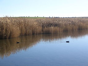
Tablas de Daimiel National Park (Parque Nacional de las Tablas de Daimiel) is a wetland on the La Mancha plain, a mainly arid area in the province of Ciudad Real. With an area of about 3,000 hectares, the park is the smallest of Spain's fifteen national parks.[3] The protected area is in the process of being expanded outside the original nature reserve to include neighbouring dryland farming areas. The expansion is part of efforts to improve the condition of the wetland, which has been damaged by over-exploitation of water resources.[1]
As well as having national park status, the site enjoys international recognition, being:
- a wetland on the list of the Ramsar Convention (1,938 ha)[4]
- the core of the Biosphere reserve Mancha Húmeda
- a Special Protection Area for birds
- ^ a b "1102 hectareas mas de parque nacional". Público. 2014. Retrieved 11 January 2014.
- ^ "Las Tablas de Daimiel". Ramsar Sites Information Service. Retrieved 25 April 2018.
- ^ "Official page of the park (Google translation)". Official site. Retrieved September 25, 2007.
- ^ Ficha Informativa sobre Humedales Ramsar