Tallahassee metropolitan area | |
|---|---|
| Tallahassee, FL Metropolitan Statistical Area Tallahassee—Bainbridge, FL-GA Combined Statistical Area | |
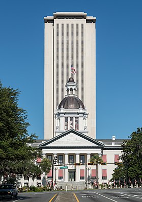
 Florida Capitol buildings (Old Capitol in foreground) | |
 | |
| Country | United States |
| State(s) | Florida Georgia |
| Counties | |
| Principal city | Tallahassee |
| Other cities | |
| Area | |
| • MSA | 2,604 sq mi (6,750 km2) |
| • CSA | 3,227 sq mi (8,360 km2) |
| Population (2020) | |
| • Total | 384,298 |
| • Estimate (2023) | 392,645 |
| • CSA (2020) | 413,665 |
| • CSA (2023) | 421,732 |
| Time zone | UTC-5 (EST) |
| • Summer (DST) | UTC-4 (EDT) |
The Tallahassee Metropolitan Area is the metropolitan area centered on Tallahassee, the capital of the U.S. state of Florida, in Leon County. It is located in the center of North Florida in the Florida panhandle.
The Tallahassee Metropolitan Statistical Area is a metropolitan statistical area (MSA) designated by the Office of Management and Budget and used by the Census Bureau and other agencies for statistical purposes. The Tallahassee Metropolitan Statistical Area consists of the following four Florida counties: Leon, Gadsden, Wakulla, and Jefferson.
The Tallahassee—Bainbridge, FL-GA Combined Statistical Area is a combined statistical area (CSA) is a primary statistical area that includes the Tallahassee, FL Metropolitan Statistical Area and the Bainbridge, GA Micropolitan Statistical Area (μSA), which consists solely of the Georgia county of Decatur.
Additionally, the Thomasville, GA μSA is immediately adjacent to the Tallahassee MSA to the northeast. The distance and driving time between the Thomasville and Tallahassee city centers during commuting hours is both five miles and 5-10 minutes shorter than those between the Bainbridge and Tallahassee city centers.[1][2]
| County | Pop. (2020)[3] | Area (mi2) | County Seat |
|---|---|---|---|
| Leon | 292,198 | 702 | Tallahassee* |
| Gadsden | 43,826 | 529 | Quincy |
| Wakulla | 33,764 | 736 | Crawfordville |
| Jefferson | 14,510 | 637 | Monticello |
| MSA | 384,298 | 2,604 | |
| Decatur | 29,367 | 623 | Bainbridge |
| CSA | 413,665 | 3,227 |
*denotes principal city in the MSA
- ^ "Bainbridge to Florida State Capitol". Google Maps. May 16, 2024.
- ^ "Thomasville to Florida State Capitol". Google Maps. May 16, 2024.
- ^ "Explore Census Data". data.census.gov. Retrieved 2024-05-16.
