Back Tanay BCL Tanay CBK-ZAM Tanay, Rizal CEB Tanay (Rizal) German Tanay (Filipinoj) Esperanto تنی، ریزال Persian Tanay (Rizal) French Tanay, Rizal ID Tanay ILO Tanay (Rizal) Italian
This article needs additional citations for verification. (March 2013) |
Tanay | |
|---|---|
| Municipality of Tanay | |
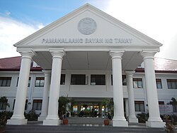
 Tanay Municipal Hall | |
| Nickname: Tourism Capital of Rizal | |
| Anthem: Tanay Dakila ka | |
 Map of Rizal with Tanay highlighted | |
Location within the Philippines | |
| Coordinates: 14°29′50″N 121°17′11″E / 14.49722°N 121.28639°E | |
| Country | Philippines |
| Region | Calabarzon |
| Province | Rizal |
| District | 2nd district |
| Founded | November 12, 1606[1] |
| Named for | "Monte de Tan-ay" |
| Barangays | 20 (see Barangays) |
| Government | |
| • Type | Sangguniang Bayan |
| • Mayor | Rafael A. Tanjuatco |
| • Vice Mayor | Rex Manuel C. Tanjuatco |
| • Representative | Emigdio P. Tanjuatco III |
| • Municipal Council | Members |
| • Electorate | 70,360 voters (2022) |
| Area | |
| • Total | 200.00 km2 (77.22 sq mi) |
| Elevation | 37 m (121 ft) |
| Highest elevation | 1,467 m (4,813 ft) |
| Lowest elevation | 1 m (3 ft) |
| Population (2020 census)[4] | |
| • Total | 139,420 |
| • Density | 700/km2 (1,800/sq mi) |
| • Households | 33,178 |
| Economy | |
| • Income class | 1st municipal income class |
| • Poverty incidence | 5.47 |
| • Revenue | ₱ 448.8 million (2020) |
| • Assets | ₱ 2,297 million (2020) |
| • Expenditure | ₱ 394.9 million (2020) |
| • Liabilities | ₱ 942.6 million (2020) |
| Service provider | |
| • Electricity | Manila Electric Company (Meralco) |
| • Water | Tanay Water District |
| Time zone | UTC+8 (PST) |
| ZIP code | 1980 |
| PSGC | |
| IDD : area code | +63 (0)2 |
| Native languages | Sinauna Tagalog |
| Major religions | Roman Catholicism |
| Feast date | January 22–24 – Tanay Town Fiesta
October 28 – Barangay Sampaloc Fiesta November – Tanay Hane Festival |
| Catholic diocese | Diocese of Antipolo |
| Patron saint | Ildephonsus of Toledo
Our Lady of Guadalupe – (Town Proper), Holy Cross – (Barangay Tandang Kutyo), Jude the Apostle – (Barangay Sampaloc), and Holy Family – (Barangay Cuyambay) |
| Website | www |
Tanay, officially the Municipality of Tanay (Tagalog: Bayan ng Tanay IPA: [tɐˈnaɪ]), is a 1st class municipality in the province of Rizal, Philippines. According to the 2020 census, it has a population of 139,420 people.[4]
Tanay is located 37 kilometres (23 mi) from Antipolo and 54 kilometres (34 mi) from Manila. It contains portions of the Sierra Madre Mountains and is bordered by Antipolo in the north-west, Baras, Morong and Teresa in the west, General Nakar (Quezon Province) in the east, and Pililla, Santa Maria (Laguna province) as well as the lake Laguna de Bay in the south.
It is the epicenter of the Tanay Tagalog dialect, which has the deepest modern Tagalog words in the Tagalog language and is the only endangered Tagalog dialect.
- ^ "Tanay Hane Festival – Municipality of Tanay, Rizal". Tanay.gov.ph. 2015-07-10. Retrieved 2019-10-26.
- ^ Municipality of Tanay | (DILG)
- ^ "2015 Census of Population, Report No. 3 – Population, Land Area, and Population Density" (PDF). Philippine Statistics Authority. Quezon City, Philippines. August 2016. ISSN 0117-1453. Archived (PDF) from the original on May 25, 2021. Retrieved July 16, 2021.
- ^ a b Census of Population (2020). "Region IV-A (Calabarzon)". Total Population by Province, City, Municipality and Barangay. Philippine Statistics Authority. Retrieved 8 July 2021.
- ^ "PSA Releases the 2021 City and Municipal Level Poverty Estimates". Philippine Statistics Authority. 2 April 2024. Retrieved 28 April 2024.


