Back Tasmansee Afrikaans Mar de Tasmania AN Tasmansǣ ANG بحر تسمان Arabic Mar de Tasmania AST Tasman dənizi Azerbaijani تاسمان دنیزی AZB Тасман диңгеҙе Bashkir Тасманава мора Byelorussian Тасманава мора BE-X-OLD
| Tasman Sea "The Ditch" | |
|---|---|
 | |
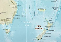
 Map of the Tasman Sea | |
| Location | Western Pacific Ocean |
| Coordinates | 40°S 160°E / 40°S 160°E |
| Type | Sea |
| Basin countries | Australia, New Zealand |
| Max. length | 2,800 km (1,700 mi) |
| Max. width | 2,200 km (1,400 mi) |
| Surface area | 2,300,000 km2 (890,000 sq mi) |
| Islands | Lord Howe Island, Norfolk Island |
| Benches | Lord Howe Rise |
| Settlements | Newcastle, Sydney, Wollongong, Hobart (Australia) Auckland, Wellington, New Plymouth, Whanganui (New Zealand) |

The Tasman Sea is a marginal sea of the South Pacific Ocean, situated between Australia and New Zealand. It measures about 2,000 km (1,200 mi) across and about 2,800 km (1,700 mi) from north to south. The sea was named after the Dutch explorer Abel Janszoon Tasman, who in 1642 was the first known person to cross it. British explorer Lieutenant James Cook later extensively navigated the Tasman Sea in the 1770s during his three voyages of exploration.[1]
The Māori people of New Zealand call this sea Te Moana-a-Rehua meaning 'the sea of Rehua' which clashes with the Pacific waters named Te Tai-o-Whitirea ('the sea of Whitirea') –after Whitirea, Rehua's lover– at Cape Reinga northernmost tip of North Island.[2] In both Australian and New Zealand English, it is nicknamed the Ditch comparable to the North Atlantic Ocean nicknamed as "the Pond"; for example, "crossing the Ditch" means travelling to Australia from New Zealand or vice versa.
- ^ "Tasman Sea". Encyclopædia Britannica. Retrieved 3 January 2018.
- ^ Mitcalfe, Barry (June 1961). "Te Rerenga Wairua - Leaping Places of the Spirits". Te Ao Hou. Maori Affairs Department New Zealand. pp. 38–42.