Back تيهاما (كاليفورنيا) Arabic تيهاما (كاليفورنيا) ARZ تهاما، کالیفورنیا AZB Тихема (град, Калифорния) Bulgarian Tehama Catalan Тегама (Калифорни) CE Tehama (lungsod sa Tinipong Bansa) CEB Tehama (California) Spanish Tehama (Kalifornia) Basque تهاما، کالیفرنیا Persian
City of Tehama | |
|---|---|
 Tehama County Museum | |
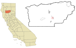
 Location in Tehama County and the state of California | |
| Coordinates: 40°1′28″N 122°7′26″W / 40.02444°N 122.12389°W | |
| Country | |
| State | |
| County | Tehama |
| Incorporated | July 5, 1906[1] |
| Area | |
• Total | 0.79 sq mi (2.06 km2) |
| • Land | 0.79 sq mi (2.06 km2) |
| • Water | 0.00 sq mi (0.00 km2) 0% |
| Elevation | 210 ft (64 m) |
| Population | |
• Total | 435 |
| • Density | 469.77/sq mi (181.31/km2) |
| Time zone | UTC-8 (Pacific (PST)) |
| • Summer (DST) | UTC-7 (PDT) |
| ZIP code | 96090 |
| Area code | 530 |
| FIPS code | 06-78106 |
| GNIS feature ID | 1659964 |
| Website | cityoftehama |
Tehama (Wintun for "high water") is a city in Tehama County, California, United States. The population was 418 at the 2010 census, down from 432 at the 2000 census.
- ^ "California Cities by Incorporation Date". California Association of Local Agency Formation Commissions. Archived from the original (Word) on October 17, 2013. Retrieved August 25, 2014.
- ^ "2019 U.S. Gazetteer Files". United States Census Bureau. Retrieved July 1, 2020.
- ^ "Explore Census Data". data.census.gov. Retrieved May 12, 2023.
