Back Terenure CEB Terenure Esperanto Terenure Basque Tír an Iúir Irish Tír an Iúir Scots/Gaelic Terenure Dutch Terenure Polish Тереньюр Russian Terenure Swedish
Terenure
Tír an Iúir | |
|---|---|
Suburb | |
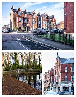
 Much of Terenure features red brick Victorian and Edwardian architecture. Bushy Park is a prominent local amenity. | |
| Coordinates: 53°18′35″N 6°17′01″W / 53.30985°N 6.2835°W | |
| Country | Ireland |
| Province | Leinster |
| County | Dublin |
| Council | Dublin City Council |
| Dáil Éireann | Dublin Bay South |
| European Parliament | Dublin |
| Elevation | 54 m (177 ft) |
| Population (2022)[1] | |
| • Electoral division | 17,972 |
| Time zone | UTC+0 (WET) |
| • Summer (DST) | UTC-1 (IST (WEST)) |
| Irish Grid Reference | O143301 |
Terenure (Irish: Tír an Iúir, meaning 'land of the yew tree'),[2] originally called Roundtown, is a middle class[3] suburb of Dublin in Ireland. It is located in the city's D6 and D6W postal districts. The population of all electoral divisions labelled as Terenure was 17,972 as of the 2022 census.[1]
- ^ a b "Census 2022 - F1008 Population by Electoral Divisions in County Dublin, by Birthplace". Central Statistics Office Census 2022 Reports. Central Statistics Office Ireland. August 2023. Retrieved 9 September 2023.
- ^ "Tír an Iúir". Placenames Database of Ireland. Department of the Environment, Heritage and Local Government. 2008. Retrieved 2 October 2008.
- ^ Freeman, Michael. "Your guide to Terenure: Victorian grandeur around a proper old village centre". TheJournal.ie. Retrieved 27 January 2022.

