Back Thornbury (bahin nga lungsod sa Ostralya) CEB ثورنبری، ویکتوریا Persian Thornbury, Bhictòria Scots/Gaelic Thornbury (Victoria) NB Thornbury (del av en befolkad plats i Australien, Victoria, Darebin) Swedish تھورنبری، وکٹوریہ Urdu
| Thornbury Melbourne, Victoria | |||||||||||||||
|---|---|---|---|---|---|---|---|---|---|---|---|---|---|---|---|
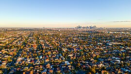
 View of Thornbury from above looking towards the Melbourne CBD | |||||||||||||||
 | |||||||||||||||
| Coordinates | 37°45′36″S 145°00′25″E / 37.760°S 145.007°E | ||||||||||||||
| Population | 19,005 (2021 census)[1] | ||||||||||||||
| • Density | 3,650/km2 (9,470/sq mi) | ||||||||||||||
| Postcode(s) | 3071 | ||||||||||||||
| Elevation | 69 m (226 ft) | ||||||||||||||
| Area | 5.2 km2 (2.0 sq mi) | ||||||||||||||
| Location | 7 km (4 mi) NE of Melbourne | ||||||||||||||
| LGA(s) | City of Darebin | ||||||||||||||
| State electorate(s) | Northcote | ||||||||||||||
| Federal division(s) | Cooper | ||||||||||||||
| |||||||||||||||
Thornbury (/ˈθɔːrnbəri/ ) is an inner-city suburb in Melbourne, Victoria, Australia, 7 km (4.3 mi) north-east of Melbourne's Central Business District, located within the City of Darebin local government area. Thornbury recorded a population of 19,005 at the 2021 census.[1]
Thornbury is bordered by the Merri Creek to the west, and the Darebin Creek to the east. The heart of Thornbury is known as Thornbury Village,[2] and is located at the centre of Thornbury, at the intersection of High Street and Normanby Avenue/Clarendon Street.
Thornbury is shaped as a thin strip of land sandwiched between Northcote and Preston. Its east–west distance is four times its north–south distance. For 111 years, Thornbury was part of the former City of Northcote local government area, which existed from 1883 until June 1994. As such, Thornbury is universally understood to be a demographic and commercial satellite of Northcote, along with Westgarth, although the latter does not have its own postcode.
In the 2021 census, the most common ancestries were English 29.7%, Australian 24.8%, Irish 14.1%, Italian 12.6% and Greek 10.9%%. 70.5% of people were born in Australia with other common countries of birth being Greece 4.2%, England 2.9%, Italy 2.9%, and New Zealand 2.2%. Most common languages, other than English spoken at home are Greek 8.0%, Italian 4.2%, Arabic 1.7%, Mandarin 1.1% and Vietnamese 1.0%.[3]
- ^ a b Australian Bureau of Statistics (28 June 2022). "Thornbury (Suburbs and Localities)". 2021 Census QuickStats. Retrieved 2 July 2022.
- ^ Thornbury Village Precinct as recognised by the City of Darebin
- ^ "Data by region | Australian Bureau of Statistics". abs.gov.au. Retrieved 18 October 2024.
