Back Tokai Afrikaans Tokai (Le Cap) French Tokai, Cape Town ID Tokai NSO ٹوکائی، کیپ ٹاؤن Urdu Tokai Xhosa Tokai Zulu
This article needs additional citations for verification. (April 2007) |
Tokai | |
|---|---|
|
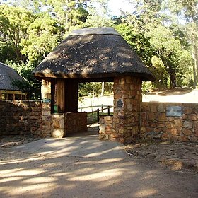
From top left, Historic Tokai manor house and vineyard. Trees in the Tokai Arboretum (top right). Entrance to the Tokai Arboretum (centre). Historic stone chapel (bottom left). View over Tokai from a local mountain biking track (bottom right). | |
 | |
| Coordinates: 34°3′45″S 18°26′30″E / 34.06250°S 18.44167°E | |
| Country | South Africa |
| Province | Western Cape |
| Municipality | City of Cape Town |
| Main Place | Cape Town |
| Area | |
| • Total | 1.05 km2 (0.41 sq mi) |
| Population (2011)[1] | |
| • Total | 2,568 |
| • Density | 2,400/km2 (6,300/sq mi) |
| Racial makeup (2011) | |
| • Black African | 10.2% |
| • Coloured | 3.8% |
| • Indian/Asian | 0.7% |
| • White | 82.2% |
| • Other | 3.0% |
| First languages (2011) | |
| • English | 92.6% |
| • Afrikaans | 4.4% |
| • Other | 3.1% |
| Time zone | UTC+2 (SAST) |
| Postal code (street) | 7966 |
| PO box | 7945 |
| Area code | 021 |
Tokai, a large residential suburb of Cape Town, South Africa, is situated on the foothills of the Constantiaberg, (a large whaleback shaped mountain in the Table Mountain range) and is bordered by Steenberg and Kirstenhof to the south, Bergvliet to the east, Constantia to the north and the SAFCOL pine tree plantations against the mountain to the west.
- ^ a b c d "Sub Place Tokai". Census 2011.


