Back Toodyay BAT-SMG Toodyay (lungsod) CEB Toodyay Danish Toodyay Estonian تودیای، استرالیای غربی Persian Toodyay French Toodyay Italian Toodyay Dutch Toodyay NB Toodyay Polish
| Toodyay Western Australia | |
|---|---|
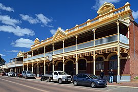
 View of Stirling Terrace, 2013 | |
 | |
| Coordinates | 31°33′S 116°27′E / 31.550°S 116.450°E |
| Population | 953 (UCL 2021)[1] |
| Established | 1860 |
| Postcode(s) | 6566 |
| Area | 62.4 km2 (24.1 sq mi) |
| Location | |
| LGA(s) | Shire of Toodyay |
| State electorate(s) | Moore |
| Federal division(s) | Pearce |
Toodyay (/ˈtuːdʒeɪ/, Nyungar: Duidgee), known as Newcastle between 1860 and 1910, is a town on the Avon River in the Wheatbelt[2][3] region of Western Australia, 85 kilometres (53 mi) north-east of Perth. The first European settlement occurred in the area in 1836. After flooding in the 1850s, the townsite was moved to its current location in the 1860s. It is connected by railway and road to Perth. During the 1860s, it was home to bushranger Moondyne Joe.
- ^ Australian Bureau of Statistics (28 June 2022). "Toodyay (urban centre and locality)". Australian Census 2021.
- ^ "Name of Town Changed". Kalgoorlie Miner. WA. 5 May 1910. p. 6. Retrieved 4 March 2014 – via National Library of Australia.
- ^ "Wheatbelt North Region". Mainroads – Western Australia. August 2008. Retrieved 30 December 2009.
