Toqua Site | |
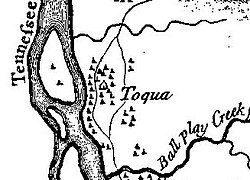
 Toqua as shown on Henry Timberlake's 1762 Draught of the Cherokee Country | |
| Location | Monroe County, Tennessee |
|---|---|
| Nearest city | Vonore |
| Coordinates | 35°34′05″N 84°10′27″W / 35.56806°N 84.17417°W |
| Built | circa 900-1000 |
| NRHP reference No. | 78002618 |
| Added to NRHP | 1978 |
Toqua (Cherokee: ᏙᏉ, romanized: Toquo) was a prehistoric and historic Native American site in Monroe County, Tennessee, located in the Southeastern Woodlands. Toqua was the site of a substantial ancestral town that thrived during the Mississippian period (1000-1600 CE). Toqua had a large earthwork 25-foot (7.6 m) platform mound built by the town's Mississippian-era inhabitants, in addition to a second, smaller mound. The site's Mississippian occupation may have been recorded by the Spanish as the village of Tali, which was documented in 1540 by the Hernando de Soto expedition.[1] It was later known as the Overhill Cherokee town Toqua, and this name was applied to the archeological site.
In 1967 an archeological survey was conducted at this site prior to completion of the Tellico Dam, as that project would result in Toqua's inundation by Tellico Lake. The Toqua site was important as one of the last remaining Dallas-phase platform mound sites in the valley.[2] In 1978 the archeological site was added to the National Register of Historic Places. In 1979 the Toqua site was submerged after the Little Tennessee River was dammed. The lake is managed by the Tennessee Valley Authority. The shoreline above the Toqua site is now a recreational area managed by the Tennessee Wildlife Resources Agency.
- ^ Charles M. Hudson, Knights of Spain, Warriors of the Sun (Athens, Georgia: University of Georgia Press, 1997), 207-215.
- ^ Polhemus, The Toqua Site, 9-12.
