Back Toro (Zamora) AN Toro AST تورو (سامرا) AZB Toro (Zamora) Breton Toro (Zamora) Catalan Торо (Самора) CE Toro (munisipyo sa Espanya, Castilla y León, Provincia de Zamora, lat 41,48, long -5,44) CEB Toro (Spanien) German Toro (Zamora) Esperanto Toro (España) Spanish
Toro | |
|---|---|
 | |
| Coordinates: 41°31′32″N 5°23′28″W / 41.52556°N 5.39111°W | |
| Country | |
| Autonomous community | |
| Province | |
| Comarca | Alfoz de Toro |
| Judicial district | Toro |
| Government | |
| • Mayor | Tomás del Bien Sánchez (PSOE) |
| Area | |
| • Total | 326 km2 (126 sq mi) |
| Elevation | 740 m (2,430 ft) |
| Population (2018)[1] | |
| • Total | 8,789 |
| • Density | 27/km2 (70/sq mi) |
| Demonym | Toresanos |
| Time zone | UTC+1 (CET) |
| • Summer (DST) | UTC+2 (CEST) |
| Postal code | 49800 |
| Dialing code | 980 |
| Website | Official website |
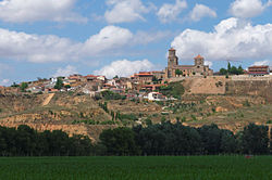
Toro is a town and municipality in the province of Zamora, part of the autonomous community of Castile and León, Spain. It is located on a fertile high plain, northwest of Madrid at an elevation of 740 metres (2,430 ft).
Toro is known as a center of Mudéjar art and as a wine-producing region. It is located on the Duero River roughly halfway between Zamora, the provincial capital and Tordesillas in the province of Valladolid. The four-lane freeway (autovía) A-11 now connects these two cities and passes just north of Toro. Highway N122 passes through the town. The distance to Madrid by highway is 220 km (137 mi). Distances to other cities are: 32 km (20 mi) to Zamora, 62 km (39 mi) to Valladolid and 72 km (45 mi) to Salamanca.
- ^ Municipal Register of Spain 2018. National Statistics Institute.


