Back Cottesloe (rehiyon) CEB Cottesloe Town German Ville de Cottesloe French Città di Cottesloe Italian Town of Cottesloe Dutch Town of Cottesloe Swedish
| Town of Cottesloe Western Australia | |||||||||||||||
|---|---|---|---|---|---|---|---|---|---|---|---|---|---|---|---|
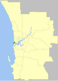
 The Town of Cottesloe within the Perth Metropolitan Area | |||||||||||||||
 | |||||||||||||||
| Population | 7,970 (LGA 2021)[1] | ||||||||||||||
| Established | 1895 | ||||||||||||||
| Area | 3.9 km2 (1.5 sq mi) | ||||||||||||||
| Mayor | Lorraine Young | ||||||||||||||
| Council seat | Cottesloe | ||||||||||||||
| Region | West Metropolitan Perth | ||||||||||||||
| State electorate(s) | Cottesloe | ||||||||||||||
| Federal division(s) | Curtin | ||||||||||||||
 | |||||||||||||||
| Website | Town of Cottesloe | ||||||||||||||
| |||||||||||||||
The Town of Cottesloe is a local government area in the western suburbs of Perth, the capital of Western Australia. It covers the suburb of the same name as well as a tiny portion of the suburb of Claremont. Cottesloe is located 11 kilometres (7 mi) west of Perth's central business district, covers an area of 3.9 square kilometres (1.5 sq mi), maintains 45.7 km of roads and had a population of approximately 7,500 as at the 2016 Census. Cottesloe is served by Swanbourne, Victoria Street, Grant Street and Cottesloe train stations, all operated through the Fremantle Railway Line. Various bus routes operate along Stirling Highway, enabling transport through the suburb's western and eastern precincts with Perth and Fremantle. All services are operated by the Public Transport Authority. The Town of Cottesloe's inclusion of walk and cycle paths enable it to be a walkable precinct.
- ^ Australian Bureau of Statistics (28 June 2022). "Cottesloe (Local Government Area)". Australian Census 2021 QuickStats. Retrieved 28 June 2022.