Back Laura ekaitz tropikala (2008) Basque Den tropiske stormen Laura NB Tempestade tropical Laura (2008) Portuguese Лаура (тропический шторм, 2008) Russian Tropical Storm Laura (2008) SIMPLE Лаура (тропічний шторм, 2008) Ukrainian 2008年热带风暴劳拉 Chinese
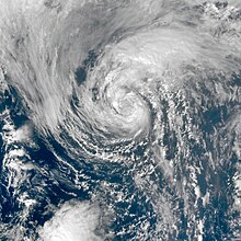
 Tropical Storm Laura at peak intensity on September 30 | |
| Meteorological history | |
|---|---|
| Formed | September 29, 2008 |
| Extratropical | October 1 |
| Dissipated | October 4, 2008 |
| Tropical storm | |
| 1-minute sustained (SSHWS/NWS) | |
| Highest winds | 60 mph (95 km/h) |
| Lowest pressure | 994 mbar (hPa); 29.35 inHg (990 mbar (29.53 inHg) while extratropical) |
| Overall effects | |
| Fatalities | None |
| Damage | Minimal |
| Areas affected | Azores, Atlantic Canada, Greenland, Europe |
| IBTrACS | |
Part of the 2008 Atlantic hurricane season | |
Tropical Storm Laura was a large but short-lived tropical cyclone that developed over the north-central Atlantic Ocean in late September during the 2008 Atlantic hurricane season. Laura's remnants later impacted the Netherlands, Germany, and Norway. The 12th named storm of the season, Laura formed out of a large extratropical area of low pressure located about 1,015 miles (1,633 km) west of the Azores on September 29. Laura slowly developed tropical characteristics throughout the day as it moved over warmer waters. On the afternoon of September 30, Laura had acquired enough tropical characteristics to be designated a tropical storm. Shortly after being declared tropical, Laura began to undergo an extratropical transition, which did not fully take place until the morning of October 1. Laura degenerated into a post-tropical cyclone later that morning, and the final advisory by the National Hurricane Center was issued. The remnants of Laura contributed to heavy rainfall and power outages in the British Isles, the Netherlands, and Norway on October 5 to 8.