Back تراوتدل Arabic تروتدل، اورقن AZB Траутдейл (град, Орегон) Bulgarian Troutdale (Oregon) Catalan Траутдейл (Орегон) CE Troutdale CEB Troutdale, Oregon Welsh Troutdale (Oregon) German Troutdale Spanish Troutdale (Oregon) Basque
Troutdale | |
|---|---|
| Troutdale, Oregon | |
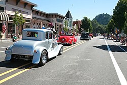
 Downtown Troutdale during SummerFest (2015) | |
 Location in Multnomah County, Oregon | |
| Coordinates: 45°31′46″N 122°22′30″W / 45.52944°N 122.37500°W | |
| Country | United States |
| State | Oregon |
| County | Multnomah |
| Incorporated | 1907 |
| Government | |
| • Mayor | Randy Lauer[1] |
| Area | |
| • Total | 6.03 sq mi (15.62 km2) |
| • Land | 5.95 sq mi (15.40 km2) |
| • Water | 0.09 sq mi (0.22 km2) |
| Elevation | 161 ft (49 m) |
| Population | |
| • Total | 16,300 |
| • Density | 2,741.34/sq mi (1,058.44/km2) |
| Time zone | UTC−8 (Pacific) |
| • Summer (DST) | UTC−7 (Pacific) |
| ZIP code | 97060 |
| Area code | 503 & 971 |
| FIPS code | 41-74850[5] |
| GNIS feature ID | 2412098[3] |
| Website | www.troutdaleoregon.gov |
Troutdale is a city in Multnomah County, Oregon, United States, immediately north of Gresham and east of Wood Village. As of the 2020 census, the city population was 16,300.[6] The city serves as the western gateway to the Historic Columbia River Highway, the Mount Hood Scenic Byway, and the Columbia River Gorge. It is approximately 12 miles (19 km) east of Portland.
- ^ https://www.troutdaleoregon.gov/directory-listing/randy-lauer
- ^ "ArcGIS REST Services Directory". United States Census Bureau. Retrieved October 12, 2022.
- ^ a b U.S. Geological Survey Geographic Names Information System: Troutdale, Oregon
- ^ Cite error: The named reference
USCensusDecennial2020CenPopScriptOnlywas invoked but never defined (see the help page). - ^ "U.S. Census website". United States Census Bureau. Retrieved January 31, 2008.
- ^ Cite error: The named reference
wwwcensusgovwas invoked but never defined (see the help page).