| Tuamotu tropical moist forests | |
|---|---|
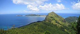
 Mont Mokoto on Mangareva | |
 Map of the Tuamotu tropical moist forests ecoregion | |
| Ecology | |
| Realm | Oceanian |
| Biome | tropical and subtropical moist broadleaf forests |
| Geography | |
| Area | 777 km2 (300 sq mi) |
| Countries | |
| Administrative subdivisions | Îles Tuamotu-Gambier |
| Conservation | |
| Conservation status | Critical/endangered[1] |
| Protected | 38 km2 (5%)[2] |
The Tuamotu tropical moist forests is a tropical and subtropical moist broadleaf forests ecoregion in the Tuamotu Archipelago of French Polynesia and the Pitcairn Islands.
- ^ "Tuamotu tropical moist forests". Terrestrial Ecoregions. World Wildlife Fund.
- ^ Dinerstein, Eric; Olson, David; et al. (June 2017). "An Ecoregion-Based Approach to Protecting Half the Terrestrial Realm". BioScience. 67 (6): 534–545. doi:10.1093/biosci/bix014. PMC 5451287. PMID 28608869.
{{cite journal}}: CS1 maint: date and year (link) Supplemental material 2 table S1b.
