Back Tully (lungsod sa Ostralya) CEB Tully (Queensland) German تولی، کوئینزلند Persian Tully (Queensland) French Tully (Australia) Polish Tully, Queensland Swedish
| Tully Queensland | |||||||||||||||
|---|---|---|---|---|---|---|---|---|---|---|---|---|---|---|---|
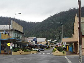
 Tully's main street, Butler Street, 2006 | |||||||||||||||
| Coordinates | 17°56′0″S 145°56′0″E / 17.93333°S 145.93333°E | ||||||||||||||
| Population | 2,368 (2021 census)[1] | ||||||||||||||
| Postcode(s) | 4854 | ||||||||||||||
| Elevation | 24 m (79 ft) | ||||||||||||||
| Location |
| ||||||||||||||
| LGA(s) | Cassowary Coast Region | ||||||||||||||
| State electorate(s) | |||||||||||||||
| Federal division(s) | Kennedy | ||||||||||||||
| |||||||||||||||
| |||||||||||||||
Tully is a rural town and locality in the Cassowary Coast Region, Queensland, Australia.[2][3] It is adjacent to the Bruce Highway, approximately 140 kilometres (87 mi) south of Cairns by road and 210 kilometres (130 mi) north of Townsville. Tully is perhaps best known for being one of the wettest towns in Australia, and home to the 7.9 m (25 ft 11 in) tall Golden Gumboot.
The Tully River, previously known as the Mackay River, was named after Surveyor-General William Alcock Tully in the 1870s. The town of Tully was named after the river when it was surveyed during the erection of the sugar mill in 1924, although the river does not flow through the town or the locality. During the previous decade, a settlement known as Banyan had grown up on the other side of Banyan Creek.
Tully is one of the larger towns of the Cassowary Coast Region. The economic base of the region is agriculture: sugar cane and bananas are the dominant crops. The sugar cane grown at the many farms in the district is processed locally at the Tully Sugar Mill, and the raw sugar produced is shipped elsewhere for further refining.
In the 2021 census, the locality of Tully had a population of 2,368 people.[1]
- ^ a b Cite error: The named reference
Census2021was invoked but never defined (see the help page). - ^ "Tully – town (entry 35296)". Queensland Place Names. Queensland Government. Retrieved 27 March 2016.
- ^ "Tully – locality (entry 45760)". Queensland Place Names. Queensland Government. Retrieved 27 March 2016.
