Back توتل Arabic توتل (جرادى) ARZ توتل، اوکلاهوما AZB Tuttle (Oklahoma) Catalan Теттл (Оклахома) CE Tuttle (lungsod sa Tinipong Bansa, Oklahoma) CEB Tuttle (Oklahoma) Spanish Tuttle (Oklahoma) Basque توتل، اکلاهما Persian Tuttle (Oklahoma) French
Tuttle, Oklahoma | |
|---|---|
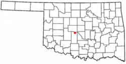
 Location of Tuttle, Oklahoma | |
| Coordinates: 35°18′25″N 97°45′23″W / 35.30694°N 97.75639°W | |
| Country | United States |
| State | Oklahoma |
| County | Grady |
| Area | |
| • Total | 29.49 sq mi (76.37 km2) |
| • Land | 29.48 sq mi (76.36 km2) |
| • Water | 0.01 sq mi (0.01 km2) |
| Elevation | 1,250 ft (380 m) |
| Population (2020) | |
| • Total | 7,413 |
| • Density | 251.45/sq mi (97.09/km2) |
| Time zone | UTC-6 (Central (CST)) |
| • Summer (DST) | UTC-5 (CDT) |
| ZIP code | 73089 |
| Area code | 405 |
| FIPS code | 40-75450 [3] |
| GNIS feature ID | 2412118[2] |
| Website | cityoftuttle.com |
Tuttle is a city in Grady County, Oklahoma, United States. The population was 7,413 with the close of the 2020 census, seeing a 23.2% increase from 6,010[Data 1] in 2010.
- ^ "ArcGIS REST Services Directory". United States Census Bureau. Retrieved September 20, 2022.
- ^ a b U.S. Geological Survey Geographic Names Information System: Tuttle, Oklahoma
- ^ "U.S. Census website". United States Census Bureau. Retrieved January 31, 2008.
Cite error: There are <ref group=Data> tags on this page, but the references will not show without a {{reflist|group=Data}} template (see the help page).