Back UMngeni Plaaslike Munisipaliteit Afrikaans Умнгени Bulgarian UMngeni CEB UMngeni Local Municipality German Municipalità locale di uMngeni Italian UMngeni Dutch Umngeni Komunie, Sud Afrika NOV Mmušôgaê wa uMngeni NSO UMngeni Polish UMasipala wase Mngeni Zulu
uMngeni | |
|---|---|
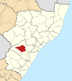
 Location in KwaZulu-Natal | |
| Country | South Africa |
| Province | KwaZulu-Natal |
| District | uMgungundlovu |
| Seat | Howick |
| Wards | 13 |
| Government | |
| • Type | Municipal council |
| • Mayor | Chris Pappas (DA) |
| • Deputy Mayor | Sandile Mnikathi (DA) |
| Area | |
| • Total | 1,567 km2 (605 sq mi) |
| Population (2022)[2] | |
| • Total | 105,069 |
| • Density | 67/km2 (170/sq mi) |
| Racial makeup (2022) | |
| • Black African | 66.7% |
| • Coloured | 2.3% |
| • Indian/Asian | 7.6% |
| • White | 22.9% |
| First languages (2011) | |
| • Zulu | 64.3% |
| • English | 25.5% |
| • Sotho | 3.8% |
| • Afrikaans | 2.1% |
| • Other | 4.3% |
| Time zone | UTC+2 (SAST) |
| Municipal code | KZN222 |
uMngeni Municipality (Zulu: UMasipala wase Mngeni) is a local municipality within the Umgungundlovu District Municipality, in the KwaZulu-Natal province of South Africa. The municipality is named after the uMngeni River that runs through the municipal area.[4]
- ^ "Contact list: Executive Mayors". Government Communication & Information System. Archived from the original on 14 July 2010. Retrieved 22 February 2012.
- ^ a b "uMngeni (Local Municipality, South Africa)". Population Statistics, Charts, Map and Location. 2022-02-02. Retrieved 2024-08-09.
- ^ "Statistics by place". Statistics South Africa. Retrieved 27 September 2015.
- ^ South African Languages - Place names
