Back يونيون سيتي (إنديانا) Arabic يونيون سيتى (راندولف) ARZ یونیون سیتی، ایندیانا AZB Union City (Indiana) Catalan Юнион-Сити (Индиана) CE Union City (lungsod sa Tinipong Bansa, Indiana) CEB Union City, Indiana Welsh Union City (Indiana) Spanish Union City (Indiana) Basque یونیون سیتی، ایندیانا Persian
Union City, Indiana | |
|---|---|
 Union City water tower and skyline | |
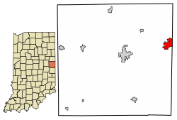
 Location of Union City in Randolph County, Indiana. | |
| Coordinates: 40°11′58″N 84°49′14″W / 40.19944°N 84.82056°W | |
| Country | United States |
| State | Indiana |
| County | Randolph |
| Township | Wayne |
| Government | |
| • Mayor | Chad E. Spence (R) |
| Area | |
| • Total | 2.27 sq mi (5.87 km2) |
| • Land | 2.26 sq mi (5.85 km2) |
| • Water | 0.01 sq mi (0.02 km2) 0.45% |
| Elevation | 1,109 ft (338 m) |
| Population (2020) | |
| • Total | 3,454 |
| • Density | 1,530.35/sq mi (590.88/km2) |
| Time zone | UTC-5 (EST) |
| • Summer (DST) | UTC-4 (EDT) |
| ZIP code | 47390 |
| Area code | 765 |
| FIPS code | 18-77768[3] |
| GNIS feature ID | 2397087[2] |
| Website | [1] |
| http://www.unioncity-in.com/ | |

Union City is a city in Wayne Township, Randolph County, Indiana, United States.[2] As of the 2020 census, the city had a population of 3,454.[4]
Union City was a stop along the Pittsburgh, Cincinnati, Chicago and St. Louis Railroad, a forerunner of the Pennsylvania Railroad that connected Pittsburgh to Chicago and St. Louis. The Cleveland, Cincinnati, Chicago and St. Louis Railway (also known as the "Big Four", a predecessor of the New York Central) had the east–west route connecting Indianapolis, Anderson and Muncie, Indiana with Sidney, Bellefontaine and Columbus, Ohio. It is believed by some area residents that the town got its nickname "The Hub City" because the two railroads intersected near the Ohio and Indiana state line.

- ^ "2020 U.S. Gazetteer Files". United States Census Bureau. Retrieved March 16, 2022.
- ^ a b c U.S. Geological Survey Geographic Names Information System: Union City, Indiana
- ^ "U.S. Census website". United States Census Bureau. Retrieved January 31, 2008.
- ^ "Explore Census Data". data.census.gov. Retrieved November 16, 2023.
