Union City | |||||||||||||||
|---|---|---|---|---|---|---|---|---|---|---|---|---|---|---|---|
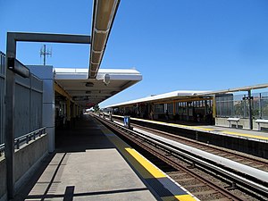
 Union City station platforms in 2017 | |||||||||||||||
| General information | |||||||||||||||
| Location | 10 Union Square Union City, California | ||||||||||||||
| Coordinates | 37°35′27″N 122°01′02″W / 37.590746°N 122.017282°W | ||||||||||||||
| Line(s) | BART A-Line | ||||||||||||||
| Platforms | 2 side platforms | ||||||||||||||
| Connections |
| ||||||||||||||
| Construction | |||||||||||||||
| Structure type | Elevated | ||||||||||||||
| Parking | 1,197 spaces[1] | ||||||||||||||
| Bicycle facilities | 20 BikeLink lockers | ||||||||||||||
| Accessible | Yes | ||||||||||||||
| Architect | Kitchen & Hunt[2] | ||||||||||||||
| History | |||||||||||||||
| Opened | September 11, 1972 | ||||||||||||||
| Rebuilt | February 12, 2014 | ||||||||||||||
| Passengers | |||||||||||||||
| 2024 | 1,767 (weekday average)[3] | ||||||||||||||
| Services | |||||||||||||||
| |||||||||||||||
| Proposed services (2030) | |||||||||||||||
| |||||||||||||||
| |||||||||||||||
Union City station is a Bay Area Rapid Transit (BART) station in Union City, California. The station sits near Decoto Road east of Alvarado-Niles Road, directly behind the James Logan High School campus. The station is served by the Orange and Green lines. Local bus service is provided by Union City Transit and AC Transit.
- ^ "Union City Station". Bay Area Rapid Transit (BART). Retrieved December 4, 2013.
- ^ Cerny, Susan Dinkelspiel (2007). An Architectural Guidebook to San Francisco and the Bay Area (1st ed.). Layton, UT: Gibbs Smith. pp. 501–502. ISBN 978-1-58685-432-4. OCLC 85623396.
- ^ "Monthly Ridership Reports". San Francisco Bay Area Rapid Transit District. February 2024.

