Back مقاطعة يونيون (ميسيسيبي) Arabic Union County, Mississippi BAR Юниън (окръг, Мисисипи) Bulgarian ইউনিয়ন কাউন্টি, মিসিসিপি BPY Union Gông (Mississippi) CDO Юнион (гуо, Миссисипи) CE Union County (kondado sa Tinipong Bansa, Mississippi) CEB Union County, Mississippi Welsh Union County (Mississippi) Danish Union County (Mississippi) German
Union County | |
|---|---|
 The Union County courthouse in New Albany | |
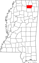
 Location within the U.S. state of Mississippi | |
 Mississippi's location within the U.S. | |
| Coordinates: 34°29′N 89°00′W / 34.49°N 89°W | |
| Country | |
| State | |
| Founded | July 7, 1870 |
| Seat | New Albany |
| Largest city | New Albany |
| Area | |
| • Total | 417 sq mi (1,080 km2) |
| • Land | 416 sq mi (1,080 km2) |
| • Water | 1.3 sq mi (3 km2) 0.3% |
| Population (2020) | |
| • Total | 27,777 |
| • Density | 67/sq mi (26/km2) |
| Time zone | UTC−6 (Central) |
| • Summer (DST) | UTC−5 (CDT) |
| Congressional district | 1st |
| Website | unioncoms |
Union County is a county located in the U.S. state of Mississippi. It was formed in 1870 from Tippah and Pontotoc counties, and in 1874 a portion of Lee County was added.[1] As of the 2020 census, the population was 27,777.[2] Its county seat is New Albany.[3] According to most sources, the county received its name by being a union of pieces of several large counties, like other Union counties in other states.[citation needed] However, other sources say that the name was meant to mark the re-union of Mississippi and the other Confederate states after the Civil War (at the time, the state had a Republican government under Reconstruction).[citation needed]
- ^ "Union County". Mississippi Encyclopedia. Retrieved April 16, 2023.
- ^ "Census - Geography Profile: Union County, Mississippi". United States Census Bureau. Retrieved January 15, 2023.
- ^ "Find a County". National Association of Counties. Retrieved June 7, 2011.