Back Upper Takutu-Upper Essequibo Region CEB Upper Takutu-Upper Essequibo German Región de Alto Tacutu-Alto Esequibo Spanish تاکوتو بالا-اسیکوییبو بالا Persian Haut-Takutu-Haut-Essequibo French Upper Takutu-Upper Essequibo FRR Takutu Hulu-Essequibo Hulu ID Alto Takutu-Alto Essequibo Italian アッパー・タクトゥ=アッパー・エセキボ州 Japanese Жоғарғы Такуту-Жоғарғы Эссекибо Kazakh
Upper Takutu-Upper Essequibo
Region 9 | |
|---|---|
Administrative Region | |
 | |
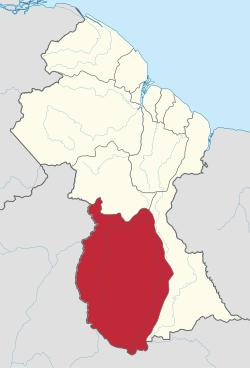
 Map of Guyana showing Upper Takutu-Upper Essequibo region | |
| Country | Claimed by |
| Regional Capital | Lethem |
| Area | |
| • Total | 57,750 km2 (22,300 sq mi) |
| Population (2012 census) | |
| • Total | 24,212 |
| • Density | 0.42/km2 (1.1/sq mi) |
| [1] | |
Upper Takutu-Upper Esequibo (Region 9) is a region of Guyana. It borders the region of Potaro-Siparuni to the north, the region of East Berbice-Corentyne to the east and Brazil to the south and west. It contains the town of Lethem, and the villages of Aishalton, Nappi and Surama. It is also the largest region of Guyana.
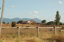
The Rupununi savannah known for its large biodiversity is located between the Rupununi River and the Brazilian border.[2] Within the Upper Takutu-Upper Esequibo is part of the Guianan savanna ecoregion.
- ^ Macmillan Publishers (2009). "Administrative Regions - 8, 9 and 10". Macmillan Junior Atlas: Guyana. Oxford: Macmillan Caribbean. p. 37. ISBN 9780333934173.
- ^ "Guyana's Rupununi Land of Nature, Authentic Culture, and Adventure". Rupununi. Retrieved 19 August 2020.
