Back نهر فخش Arabic Vaxş çayı Azerbaijani Salog Vakhsh BCL Вахш Byelorussian Вахш (река) Bulgarian ভাখশ নদী Bengali/Bangla Vakhx Catalan Vakhsh (suba) CEB Vachš Czech Vakhsj Danish
| Vakhsh | |
|---|---|
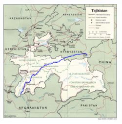
 The river Vakhsh (highlighted in blue) | |
| Location | |
| Country | Kyrgyzstan, Tajikistan |
| Physical characteristics | |
| Mouth | Amu Darya |
• coordinates | 37°06′40″N 68°18′51″E / 37.1112°N 68.3141°E |
| Length | 786 km (488 mi) |
| Basin size | 39,100 km2 (15,100 sq mi) |
| Discharge | |
| • average | 621 m3/s (21,900 cu ft/s)[1] |
| Basin features | |
| Progression | Amu Darya→ Aral Sea |

The Vakhsh (Persian: وخش; Tajik and Russian: Вахш), also known as the Surkhob (Tajik: Сурхоб; Persian: سرخاب) in north-central Tajikistan and as the Kyzyl-Suu (Kyrgyz: Кызыл-Суу) in Kyrgyzstan, is a Central Asian river and one of the main rivers of Tajikistan. It is a tributary of the Amu Darya river.[2]
- ^ "Vakhsh at Golovnaya Hyd'Elec'Power". Soviet Union Hydro-Station archive. UNESCO. 1936–1985. Retrieved 2014-02-01.
- ^ "Tajikistan - Topography and Drainage" in Tajikistan: a Country Study (Washington: Library of Congress, 1996)