Back Vandalia-Kolonie German Vandalia (Colonia) Spanish Vandalia (colonia) Italian Vandalia (colônia) Portuguese Вандалия (колония) Russian

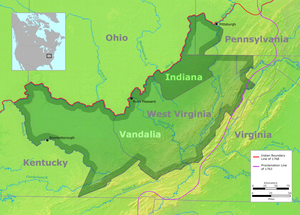
Vandalia was the name in the late 1700s of a proposed British colony in North America. The colony would have been located south of the Ohio River, primarily in what are now West Virginia and northeastern Kentucky.
Vandalia was never approved by the British Crown and had no colonial government, although some Virginians and Pennsylvanians had already settled there. After the American Revolutionary War, the Vandalia settlers sought unsuccessfully to be admitted as a state called Westsylvania. However, they had no legal title to the land and were opposed by the governments of Virginia and Pennsylvania, which both claimed the area as their own under colonial charters. Ultimately the federal government split the area between Pennsylvania and Virginia according to the Mason–Dixon line.[1] Kentucky was later settled by Virginians and admitted as a state; West Virginia was admitted as a state during the American Civil War.
- ^ Cranmer, History of the Upper Ohio, 1:59–63