Back Villavicencio Afrikaans فيلافيسنسيو Arabic Vilyavisensio Azerbaijani Вилявисенсио Bulgarian Villavicencio Catalan Villavicencio (munisipyo) CEB Villavicencio Czech Villavicencio German Villavicencio Esperanto Villavicencio Spanish
This article has multiple issues. Please help improve it or discuss these issues on the talk page. (Learn how and when to remove these messages)
|
Villavicencio | |
|---|---|
Municipality and city | |
From the top: Panoramic, The axe Park, Christ the King Monument, The harps monument | |
| Nickname(s): Puerta del Llano (Gate of the Plain) Villavo la bella (Villavo the beautiful) La Capital de la tierra Llanera (The Capital of the Llanera Land) El Corazón del Este (The Heart of the East) | |
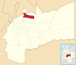
 Location map of the municipality and city of Villavicencio in the Department of Meta. | |
| Coordinates: 4°9′N 73°38′W / 4.150°N 73.633°W | |
| Country | |
| Region | Orinoquía |
| Department | |
| Founded | 1840 |
| Government | |
| • Mayor | Juan Felipe Harman |
| Area | |
• Municipality and city | 1,328 km2 (513 sq mi) |
| • Urban | 65.83 km2 (25.42 sq mi) |
| Elevation | 467 m (1,532 ft) |
| Population (2018 Census[1]) | |
• Municipality and city | 531,275 |
| • Density | 400/km2 (1,000/sq mi) |
| • Urban | 492,052 |
| • Urban density | 7,500/km2 (19,000/sq mi) |
| Demonym | Villavicense |
| Time zone | UTC-05 (Eastern Time Zone) |
| Area code | +57 (8) |
| Climate | Af |
| Website | Official website (in Spanish) |
Villavicencio (Spanish pronunciation: [biʎaβiˈsensjo]) is a city and municipality in Colombia. The capital of Meta Department, it was founded on April 6, 1840. The municipality had a population of 531,275 in 2018.[1] The city is located at 4°08'N, 73°40'W, 75 km (about 45 mi) southeast of the Colombian capital city of Bogotá (DC) by the Guatiquía River. It is the most important commercial center in the Llanos Orientales (Eastern plains) of Colombia.
Villavicencio has a hot and very wet climate, with average daily temperatures ranging from 21 to 30 °C (70 to 86 °F) and an annual rainfall of around 4,500 millimetres or 180 inches. It is affectionately called "Villavo" la bella. Villavicencio lies on the great Colombian-Venezuelan plain called the Llanos, situated to the east of the Andes mountains. Villavicencio is also called "La Puerta al Llano", or "The Gateway to the Plains", due to its location on the historical path from the Colombian interior to the vast savannas that lie between the Andes range and the Amazon rainforest.
Villavicencio's proximity to huge mountains and great plains make the city an example of Colombia's geodiversity. Because it is located in the foothills of the Andes, the morning and evening breezes cool the city, which is very hot for most of the day.
- ^ a b "INFORMACIÓN CAPITAL" (PDF) (in Spanish). Departamento Administrativo Nacional de Estadística (DANE) of Colombia.


