Back 8.º distrito congresional de Virginia Spanish حوزه انتخابیه هشتم ویرجینیا Persian Huitième district congressionnel de Virginie French 維珍尼亞州第八國會選區 Chinese
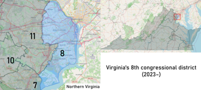
| Virginia's 8th congressional district | |
|---|---|
Interactive map of district boundaries since 2023 | |
| Representative | |
| Distribution |
|
| Population (2023) | 769,124[2] |
| Median household income | $125,354[3] |
| Ethnicity |
|
| Cook PVI | D+26[4] |

Virginia's 8th congressional district is a U.S. congressional district located just across the Potomac River from Washington, D.C. It comprises several populous cities and suburbs in Northern Virginia, including all of Alexandria, Arlington, and Falls Church, as well as parts of Fairfax County. Democrat Don Beyer has held the seat since 2015. With a Cook Partisan Voting Index rating of D+26, it is the most Democratic district in Virginia.[4]
The 8th district is heavily influenced by the federal government in neighboring Washington, with nearly a quarter of its working population employed in the public sector. Though commuting into the nation's capital for work is common, several government agencies have their headquarters in the 8th district. The most prominent of these are the United States Department of Defense (located in the Pentagon) and the Central Intelligence Agency. Their presence has established a flourishing aerospace and defense industry in the area, with Northrop Grumman being one of the district's top private sector employers. Other major corporations are also located within its boundaries, most notably AES.
The seat has long been a liberal stronghold, having backed every Democratic presidential nominee since 1992. But those margins have grown dramatically; in 2020, Joe Biden carried the 8th district by over 55 points. Once a popular destination for white flight, the district has seen an influx of Asian, Black, and Hispanic residents in recent years and is now majority nonwhite.[5] It also has the nation's fifth-highest share of individuals with a bachelor's degree or higher, in large part due to the nearby government presence.
- ^ "Congressional Districts Relationship Files (state-based)". www.census.gov. US Census Bureau Geography. Retrieved April 10, 2018.
- ^ "My Congressional District". www.census.gov. Center for New Media & Promotion (CNMP), US Census Bureau. Retrieved September 22, 2024.
- ^ "My Congressional District".
- ^ a b "2022 Cook PVI: District Map and List". Cook Political Report. Retrieved January 10, 2023.
- ^ Feinberg, Lawrence (March 11, 1981). "N.Va. Minority Population Grew Sharply in 1970s". The Washington Post. Retrieved May 18, 2023.

