| Vogel State Park | |
|---|---|
IUCN category V (protected landscape/seascape) | |
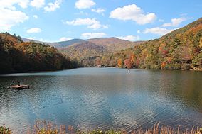
 View of Lake Trahlyta | |
| Nearest city | Blairsville, Georgia |
| Coordinates | 34°45′46″N 83°55′40″W / 34.762778°N 83.927778°W |
| Area | 233 acres (0.94 km2) |
| Established | 1931 |
| Governing body | Georgia Department of Natural Resources |
Vogel State Park is a 233-acre (0.94 km2) or 94 hectares state park located at the base of Blood Mountain in the Chattahoochee National Forest. It became one of the first two parks in Georgia when it founded a state park system in 1931.[1][2] Much of the park was constructed by the Civilian Conservation Corps during the 1930s.
The park features streams, a waterfall, and Lake Trahlyta.[3] At 2,500 feet (760 m) elevation it is one of Georgia's highest altitude state parks. The mountainous habitats surrounding the lake support a wide assortment of plants and animals.
Within the park are a series of hiking trails. These include the Bear Hair Gap Trail and the more strenuous Coosa Backcountry Trail, which leads up toward Blood Mountain and the Appalachian Trail near Neel Gap. Vogel Park features camping sites, cabins, swimming, boating and other recreational activities.

- ^ "Vogel State Park". NorthGeorgia.com. Golden Ink. Retrieved February 28, 2008.
- ^ Ethelene Dyer Jones. "Vogel State Park's 75th Anniversary". unionsentinel.com. Union Sentinel. Retrieved July 7, 2008.
- ^ Pfitzer (2006), p. 132


