Back Vorderrhein ALS نهر ڤورديرين ARZ Vorderrhein CEB Vorderrhein Danish Vorderrhein German Rin anterior Spanish Vorderrhein Finnish Rhin antérieur French Reno Anteriore Italian 포더라인강 Korean
| Vorderrhein Anterior Rhine | |
|---|---|
 The Vorderrhein in the Ruinaulta gorge | |
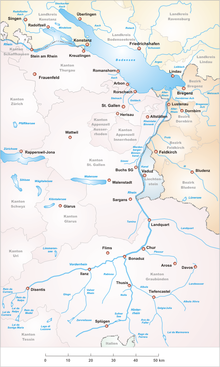
 Area of the Alpine Rhine with its headwaters | |
| Native name |
|
| Location | |
| Country | Switzerland |
| Canton | Grisons |
| Physical characteristics | |
| Source | |
| • location | Lai Urlaun |
| • coordinates | 46°37′34″N 8°41′04″E / 46.62611°N 8.68444°E |
| Mouth | |
• location | Reichenau |
• coordinates | 46°49′24″N 9°24′28″E / 46.82333°N 9.40778°E |
• elevation | 585 m (1,919 ft) |
| Length | 76 km (47 mi) |
| Basin size | 1,512 km2 (584 sq mi) |
| Discharge | |
| • average | 53.8 m3/s (1,900 cu ft/s) |
| Basin features | |
| Progression | Rhine→ North Sea |
| Tributaries | |
| • left | Aua da Russein, Flem, Schmuèr, Ual da Mulin |
| • right | Glenner, Rabiusa, Rein da Curnera, Rein da Medel, Rein da Nalps, Rein da Sumvitg |
The Vorderrhein (German: [ˈfɔʁdɐˌʁaɪn] ; Sursilvan: ; Sutsilvan: Ragn Anteriur; Rumantsch Grischun, Vallader, and Puter: Rain Anteriur; Surmiran: Ragn anteriour), or Anterior Rhine, is the left of the two initial tributaries of the Rhine (the other being the Hinterrhein). It is longer than the Hinterrhein, but has a lower discharge than the latter at their confluence, which marks the beginning of the Alpine Rhine section.
The Vorderrhein and nearly all of its tributaries are located in the Swiss canton of Grisons (Graubünden), with the largest communities along the river being Disentis and Ilanz. One of its upper tributaries, the Rein da Medel, rises in the canton of Ticino.
Vorderrhein was also the name of a judicial district that was created in 1851 with the reorganization of the judiciary of Graubünden. In 2001, it was annexed by the District Surselva.