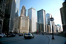
 Upper Wacker Drive, looking west from Michigan Avenue | |
 Wacker Drive highlighted in red | |
| Former name(s) | Market Street Water Street River Street |
|---|---|
| Length | 2.2 mi (3.5 km)[1] |
| South end | Upper Wacker: Franklin Street/Harrison Street intersection (360 west at 424 south) Lower Wacker: Ida B. Wells Drive near Wells Street (220 west at 400 south) |
| East end | |
| Construction | |
| Inauguration | 1926 |
Wacker Drive is a major multilevel street in Chicago, Illinois, running along the south side of the main branch and the east side of the south branch of the Chicago River in the Loop.[2] The vast majority of the street is double-decked; the upper level is intended for local traffic, and the lower level for through-traffic and trucks serving buildings on the road (and originally a dock). It is sometimes cited as a precursor to the freeway, though when it was built, the idea was that pleasure vehicles would use the upper level. It is the only street in the city that is prefixed with all four cardinal directions, albeit on different parts of its route.[a] The drive is named for early 20th century Chicago businessman and city planner Charles H. Wacker.
The upper level is normally known as Upper Wacker Drive and the lower level is Lower Wacker Drive. A short part has a third level, sometimes called Lower Lower Wacker Drive[3] or Sub Lower Wacker Drive.
- ^ Google Maps estimate.
- ^ Hayner, Don and Tom McNamee, Streetwise Chicago, "Wacker Drive", p. 129., Loyola University Press, 1988, ISBN 0-8294-0597-6
- ^ Brown, Mark. "Lower Wacker Homeless Coming to Uptown". Uptown Update. Retrieved 7 Feb. 2012.
Cite error: There are <ref group=lower-alpha> tags or {{efn}} templates on this page, but the references will not show without a {{reflist|group=lower-alpha}} template or {{notelist}} template (see the help page).
