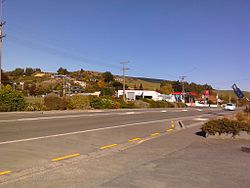
Waihola
Waihora (Māori) | |
|---|---|
Town | |
 Main street of Waihola | |
 | |
| Coordinates: 46°2′0″S 170°6′0″E / 46.03333°S 170.10000°E | |
| Country | New Zealand |
| Region | Otago |
| District | Clutha |
| Ward | Bruce |
| Electorates |
|
| Government | |
| • Territorial authority | Clutha District Council |
| • Regional council | Otago Regional Council |
| • Mayor of Clutha | Bryan Cadogan |
| • Taieri MP | Ingrid Leary |
| • Te Tai Tonga MP | Tākuta Ferris |
| Area | |
| • Total | 1.63 km2 (0.63 sq mi) |
| Population (June 2024)[2] | |
| • Total | 510 |
| • Density | 310/km2 (810/sq mi) |
| Urban PO Box Lobby Postcode (Waihola, Waihola) | 9243 |
| Rural Delivery Postcode (RD 1, Outram) | 9073 |
| International telephone access and area code | 03 |
| ISO 3166 code | 554 |
| Local iwi | Ngāi Tahu |
| [3][4][5] | |
The township of Waihola lies between Dunedin and Milton, New Zealand in Otago, in New Zealand's South Island.[3] It lies close to the southeast shore of the shallow tidal lake which shares its name.
The town is located on State Highway 1, and the South Island Main Trunk rail line runs through it, though trains no longer stop. The township is within the boundaries of Clutha District.
- ^ Cite error: The named reference
Areawas invoked but never defined (see the help page). - ^ "Aotearoa Data Explorer". Statistics New Zealand. Retrieved 26 October 2024.
- ^ a b "New Zealand Gazetteer: Search for Place Names | Land Information New Zealand (LINZ)". linz.govt.nz. Retrieved 14 June 2016.
- ^ mao(B)/mri(T) native language
- ^ "New Zealand Post". nzpost.co.nz. Retrieved 14 June 2016.
