Back Waikato District CEB Waikato District German District du Waikato French Waikato kerület Hungarian Distretto di Waikato Italian Daerah Waikato Malay Waikato District NN ضلع وائیکاٹو PNB 怀卡托区 Chinese
Waikato District | |
|---|---|
 | |
 Waikato district within the North Island | |
| Coordinates: 37°36′S 175°12′E / 37.6°S 175.2°E | |
| Country | New Zealand |
| Region | Waikato |
| Wards | Tuakau-Pōkeno, Western Districts, Awaroa-Maramarua, Waerenga-Whitikahu, Tamahere-Woodlands, Huntly, Newcastle-Ngāruawāhia, Whāingaroa, Tai Raro Takiwaa (Māori) |
| Seat | Ngāruawāhia |
| Government | |
| • Mayor | Jacqui Church |
| • Deputy Mayor | Carolyn Eyre |
| • Territorial authority | Waikato District Council |
| Area | |
| • Land | 4,404.07 km2 (1,700.42 sq mi) |
| Population (June 2024)[2] | |
| • Total | 92,500 |
| Time zone | UTC+12 (NZST) |
| • Summer (DST) | UTC+13 (NZDT) |
| Postcode(s) | |
| Website | Waikato District Council |
Waikato District is a territorial authority of New Zealand, in the northern part of Waikato region, North Island. Waikato District is administered by the Waikato District Council, with headquarters in Ngāruawāhia.
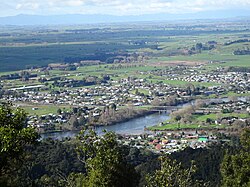
The district is centred to the north and west of the city of Hamilton, and takes in much of the northern Waikato Plains and also the Hakarimata Range. The north of the district contains swampy floodplain of the Waikato River and several small lakes, of which the largest is Lake Waikare.
Other than Ngāruawāhia, the main population centres are Huntly, Raglan, and Te Kauwhata. The main industries in the district are dairy farming, forestry, and coal mining. There is a major coal-fired power station at Huntly. Te Kauwhata is at the centre of a major wine region.
- ^ Cite error: The named reference
Areawas invoked but never defined (see the help page). - ^ "Aotearoa Data Explorer". Statistics New Zealand. Retrieved 26 October 2024.